You are here: Home > Network List > GE - GEOFON Stations List
> Station MHV GEOFON Station Michnevo, Russia > Earthquake Result Viewer
MHV GEOFON Station Michnevo, Russia - Earthquake Result Viewer
| Earthquake location: |
Halmahera, Indonesia |
| Earthquake latitude/longitude: |
-1.9/127.9 |
| Earthquake time(UTC): |
1997/06/24 (175) 23:04:53 GMT |
| Earthquake Depth: |
33 km |
| Earthquake Magnitude: |
5.9 MB, 6.1 MS, 6.4 UNKNOWN, 6.1 MS |
| Earthquake Catalog/Contributor: |
WHDF/NEIC |
|
| Network: |
GE GEOFON |
| Station: |
MHV GEOFON Station Michnevo, Russia |
| Lat/Lon: |
54.96 N/37.77 E |
| Elevation: |
150 m |
|
| Distance: |
91.6 deg |
| Az: |
324.762 deg |
| Baz: |
90.994 deg |
| Ray Param: |
0.041571073 |
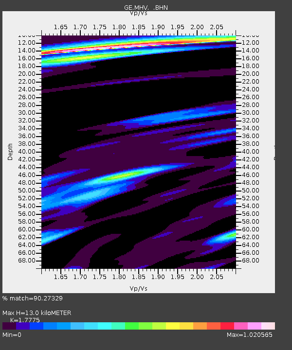
| Estimated Moho Depth: |
13.0 km |
| Estimated Crust Vp/Vs: |
1.78 |
| Assumed Crust Vp: |
6.516 km/s |
| Estimated Crust Vs: |
3.666 km/s |
| Estimated Crust Poisson's Ratio: |
0.27 |
|
| Radial Match: |
90.27329 % |
| Radial Bump: |
400 |
| Transverse Match: |
76.11774 % |
| Transverse Bump: |
400 |
| SOD ConfigId: |
6273 |
| Insert Time: |
2010-03-09 06:31:29.831 +0000 |
| GWidth: |
2.5 |
| Max Bumps: |
400 |
| Tol: |
0.001 |
|

Signal To Noise
| Channel | StoN | STA | LTA |
| GE:MHV: :BHN:19970624T23:17:25.565027Z | 1.4793879 | 1.03109514E-7 | 6.9697414E-8 |
| GE:MHV: :BHE:19970624T23:17:25.565027Z | 2.1555853 | 1.7591142E-7 | 8.160727E-8 |
| GE:MHV: :BHZ:19970624T23:17:25.565027Z | 5.966405 | 5.8455726E-7 | 9.797479E-8 |
| Arrivals |
| Ps | 1.6 SECOND |
| PpPs | 5.4 SECOND |
| PsPs/PpSs | 7.0 SECOND |


