You are here: Home > Network List > GE - GEOFON Stations List
> Station MHV GEOFON Station Michnevo, Russia > Earthquake Result Viewer
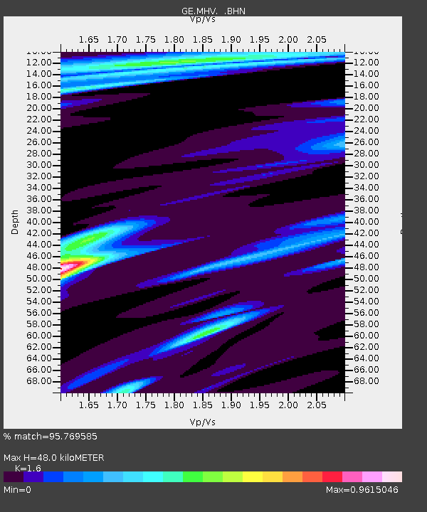
MHV GEOFON Station Michnevo, Russia - Earthquake Result Viewer
| Earthquake location: |
Xizang |
| Earthquake latitude/longitude: |
35.1/87.3 |
| Earthquake time(UTC): |
1997/11/08 (312) 10:02:52 GMT |
| Earthquake Depth: |
33 km |
| Earthquake Magnitude: |
6.2 MB, 7.9 MS, 7.7 UNKNOWN, 7.6 MW |
| Earthquake Catalog/Contributor: |
WHDF/NEIC |
|
| Network: |
GE GEOFON |
| Station: |
MHV GEOFON Station Michnevo, Russia |
| Lat/Lon: |
54.96 N/37.77 E |
| Elevation: |
150 m |
|
| Distance: |
39.3 deg |
| Az: |
316.099 deg |
| Baz: |
99.529 deg |
| Ray Param: |
0.075016245 |
| Estimated Moho Depth: |
48.0 km |
| Estimated Crust Vp/Vs: |
1.60 |
| Assumed Crust Vp: |
6.516 km/s |
| Estimated Crust Vs: |
4.073 km/s |
| Estimated Crust Poisson's Ratio: |
0.18 |
|
| Radial Match: |
95.769585 % |
| Radial Bump: |
199 |
| Transverse Match: |
75.8007 % |
| Transverse Bump: |
395 |
| SOD ConfigId: |
6273 |
| Insert Time: |
2010-03-09 06:31:36.435 +0000 |
| GWidth: |
2.5 |
| Max Bumps: |
400 |
| Tol: |
0.001 |
|

Signal To Noise
| Channel | StoN | STA | LTA |
| GE:MHV: :BHN:19971108T10:09:47.727014Z | 2.1669595 | 3.2031585E-7 | 1.478181E-7 |
| GE:MHV: :BHE:19971108T10:09:47.727014Z | 7.868656 | 1.9906367E-6 | 2.5298306E-7 |
| GE:MHV: :BHZ:19971108T10:09:47.727014Z | 19.848812 | 5.0627405E-6 | 2.5506517E-7 |
| Arrivals |
| Ps | 4.8 SECOND |
| PpPs | 18 SECOND |
| PsPs/PpSs | 22 SECOND |


