You are here: Home > Network List > N4 - Central and EAstern US Network Stations List
> Station U49A Red Boiling Springs, TN, USA > Earthquake Result Viewer
U49A Red Boiling Springs, TN, USA - Earthquake Result Viewer
| Earthquake location: |
Off East Coast Of Kamchatka |
| Earthquake latitude/longitude: |
54.7/163.2 |
| Earthquake time(UTC): |
2021/03/16 (075) 18:38:22 GMT |
| Earthquake Depth: |
22 km |
| Earthquake Magnitude: |
6.6 mww |
| Earthquake Catalog/Contributor: |
NEIC PDE/us |
|
| Network: |
N4 Central and EAstern US Network |
| Station: |
U49A Red Boiling Springs, TN, USA |
| Lat/Lon: |
36.51 N/85.78 W |
| Elevation: |
234 m |
|
| Distance: |
71.7 deg |
| Az: |
52.403 deg |
| Baz: |
325.192 deg |
| Ray Param: |
0.05417066 |
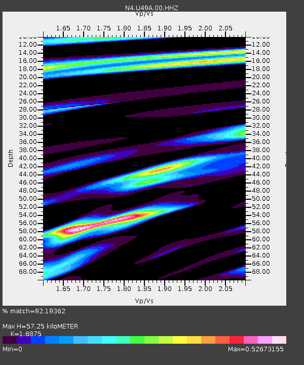
| Estimated Moho Depth: |
57.25 km |
| Estimated Crust Vp/Vs: |
1.69 |
| Assumed Crust Vp: |
6.476 km/s |
| Estimated Crust Vs: |
3.838 km/s |
| Estimated Crust Poisson's Ratio: |
0.23 |
|
| Radial Match: |
92.19362 % |
| Radial Bump: |
400 |
| Transverse Match: |
75.024506 % |
| Transverse Bump: |
400 |
| SOD ConfigId: |
24334971 |
| Insert Time: |
2021-03-30 18:55:11.879 +0000 |
| GWidth: |
2.5 |
| Max Bumps: |
400 |
| Tol: |
0.001 |
|

Signal To Noise
| Channel | StoN | STA | LTA |
| N4:U49A:00:HHZ:20210316T18:49:11.550021Z | 3.0027564 | 6.1572206E-7 | 2.0505229E-7 |
| N4:U49A:00:HH1:20210316T18:49:11.550021Z | 2.5926874 | 3.2610026E-7 | 1.2577694E-7 |
| N4:U49A:00:HH2:20210316T18:49:11.550021Z | 1.4770442 | 2.3228202E-7 | 1.572614E-7 |
| Arrivals |
| Ps | 6.3 SECOND |
| PpPs | 23 SECOND |
| PsPs/PpSs | 29 SECOND |


