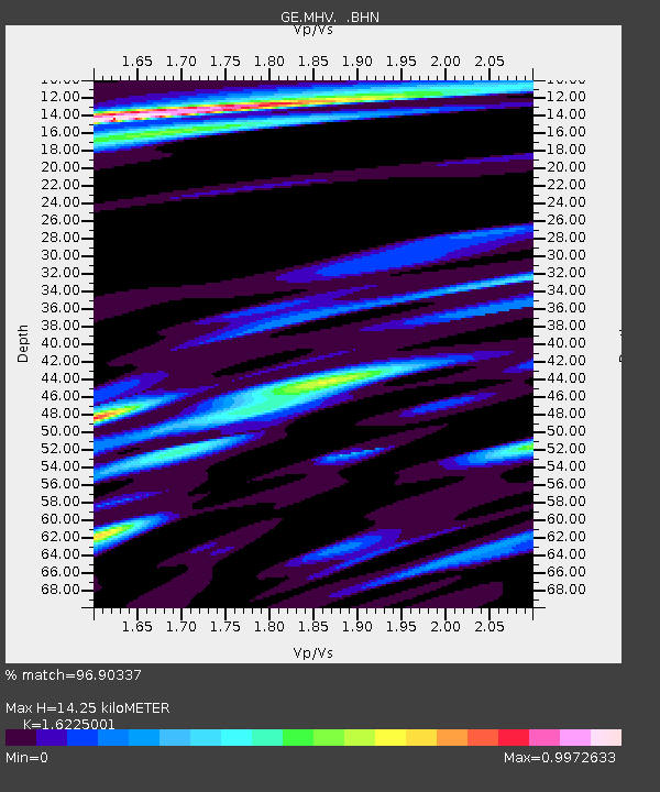
MHV GEOFON Station Michnevo, Russia - Earthquake Result Viewer

Earthquake location: Minahassa Peninsula, Sulawesi
Earthquake latitude/longitude: 0.2/119.6
Earthquake time(UTC): 1998/05/21 (141) 05:34:25 GMT
Earthquake Depth: 33 km
Earthquake Magnitude: 6.2 MB, 6.3 MS, 6.6 UNKNOWN, 6.6 MW
Earthquake Catalog/Contributor: WHDF/NEIC
Network: GE GEOFON
Station: MHV GEOFON Station Michnevo, Russia
Lat/Lon: 54.96 N/37.77 E
Elevation: 150 m
Distance: 85.1 deg
Az: 325.044 deg
Baz: 96.581 deg
Ray Param: 0.044947185
Estimated Moho Depth: 14.25 km
Estimated Crust Vp/Vs: 1.62
Assumed Crust Vp: 6.516 km/s
Estimated Crust Vs: 4.016 km/s
Estimated Crust Poisson's Ratio: 0.19
Radial Match: 96.90337 %
Radial Bump: 347
Transverse Match: 93.49635 %
Transverse Bump: 394
SOD ConfigId: 4480
Insert Time: 2010-03-09 06:31:38.784 +0000
GWidth: 2.5
Max Bumps: 400
Tol: 0.001

Signal To Noise

ChannelStoNSTALTA
GE:MHV: :BHN:19980521T05:46:26.966003Z5.57706641.1725457E-62.1024417E-7
GE:MHV: :BHE:19980521T05:46:26.966003Z1.1639151.6400763E-71.4091032E-7
GE:MHV: :BHZ:19980521T05:46:26.966003Z1.45241922.496518E-71.718869E-7
Arrivals
Ps1.4 SECOND
PpPs5.6 SECOND
PsPs/PpSs7.0 SECOND