You are here: Home > Network List > GE - GEOFON Stations List
> Station MHV GEOFON Station Michnevo, Russia > Earthquake Result Viewer
MHV GEOFON Station Michnevo, Russia - Earthquake Result Viewer
| Earthquake location: |
Off East Coast Of Kamchatka |
| Earthquake latitude/longitude: |
52.2/159.5 |
| Earthquake time(UTC): |
1998/05/27 (147) 20:41:37 GMT |
| Earthquake Depth: |
60 km |
| Earthquake Magnitude: |
5.5 MB, 6.0 UNKNOWN, 5.9 MW |
| Earthquake Catalog/Contributor: |
WHDF/NEIC |
|
| Network: |
GE GEOFON |
| Station: |
MHV GEOFON Station Michnevo, Russia |
| Lat/Lon: |
54.96 N/37.77 E |
| Elevation: |
150 m |
|
| Distance: |
62.8 deg |
| Az: |
326.531 deg |
| Baz: |
36.016 deg |
| Ray Param: |
0.0598679 |
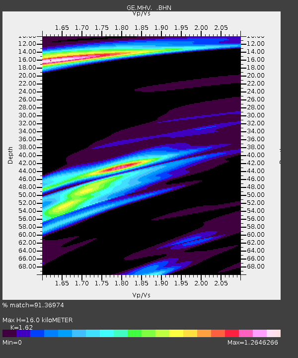
| Estimated Moho Depth: |
16.0 km |
| Estimated Crust Vp/Vs: |
1.62 |
| Assumed Crust Vp: |
6.516 km/s |
| Estimated Crust Vs: |
4.022 km/s |
| Estimated Crust Poisson's Ratio: |
0.19 |
|
| Radial Match: |
91.36974 % |
| Radial Bump: |
336 |
| Transverse Match: |
77.214066 % |
| Transverse Bump: |
400 |
| SOD ConfigId: |
4480 |
| Insert Time: |
2010-03-09 06:31:42.987 +0000 |
| GWidth: |
2.5 |
| Max Bumps: |
400 |
| Tol: |
0.001 |
|

Signal To Noise
| Channel | StoN | STA | LTA |
| GE:MHV: :BHN:19980527T20:51:26.253027Z | 15.267205 | 1.1268505E-6 | 7.3808565E-8 |
| GE:MHV: :BHE:19980527T20:51:26.253027Z | 9.613206 | 5.501614E-7 | 5.7229755E-8 |
| GE:MHV: :BHZ:19980527T20:51:26.253027Z | 7.145299 | 4.8505734E-7 | 6.788482E-8 |
| Arrivals |
| Ps | 1.6 SECOND |
| PpPs | 6.1 SECOND |
| PsPs/PpSs | 7.7 SECOND |


