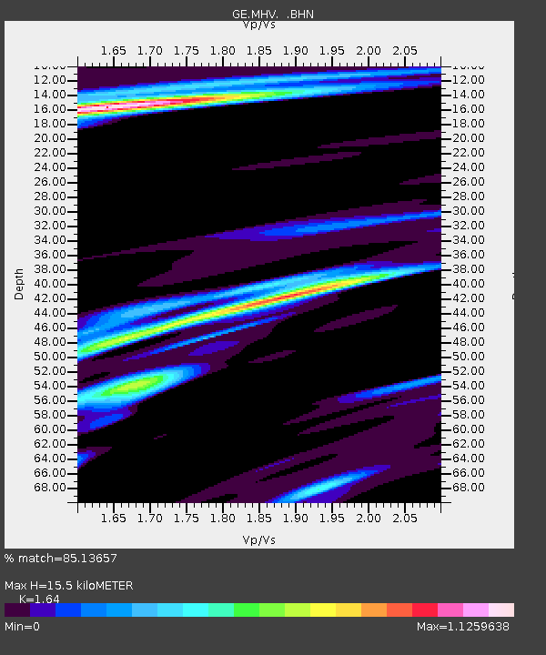
MHV GEOFON Station Michnevo, Russia - Earthquake Result Viewer

Earthquake location: Near East Coast Of Honshu, Japan
Earthquake latitude/longitude: 35.4/140.5
Earthquake time(UTC): 1998/06/14 (165) 13:17:08 GMT
Earthquake Depth: 45 km
Earthquake Magnitude: 5.5 MB, 5.3 MS, 5.8 UNKNOWN, 5.8 MW
Earthquake Catalog/Contributor: WHDF/NEIC
Network: GE GEOFON
Station: MHV GEOFON Station Michnevo, Russia
Lat/Lon: 54.96 N/37.77 E
Elevation: 150 m
Distance: 68.5 deg
Az: 322.797 deg
Baz: 58.956 deg
Ray Param: 0.056187402
Estimated Moho Depth: 15.5 km
Estimated Crust Vp/Vs: 1.64
Assumed Crust Vp: 6.516 km/s
Estimated Crust Vs: 3.973 km/s
Estimated Crust Poisson's Ratio: 0.20
Radial Match: 85.13657 %
Radial Bump: 400
Transverse Match: 75.351974 %
Transverse Bump: 400
SOD ConfigId: 4480
Insert Time: 2010-03-09 06:31:45.624 +0000
GWidth: 2.5
Max Bumps: 400
Tol: 0.001

Signal To Noise

ChannelStoNSTALTA
GE:MHV: :BHN:19980614T13:27:34.752014Z4.22635.209149E-71.2325555E-7
GE:MHV: :BHE:19980614T13:27:34.752014Z3.26287482.0625558E-76.321284E-8
GE:MHV: :BHZ:19980614T13:27:34.752014Z3.6819762.133294E-75.7938834E-8
Arrivals
Ps1.6 SECOND
PpPs6.0 SECOND
PsPs/PpSs7.6 SECOND