You are here: Home > Network List > GE - GEOFON Stations List
> Station MHV GEOFON Station Michnevo, Russia > Earthquake Result Viewer
MHV GEOFON Station Michnevo, Russia - Earthquake Result Viewer
| Earthquake location: |
Azores Islands, Portugal |
| Earthquake latitude/longitude: |
38.7/-28.6 |
| Earthquake time(UTC): |
1998/07/09 (190) 05:19:07 GMT |
| Earthquake Depth: |
10 km |
| Earthquake Magnitude: |
5.7 MB, 6.0 MS, 6.6 UNKNOWN, 6.2 MW |
| Earthquake Catalog/Contributor: |
WHDF/NEIC |
|
| Network: |
GE GEOFON |
| Station: |
MHV GEOFON Station Michnevo, Russia |
| Lat/Lon: |
54.96 N/37.77 E |
| Elevation: |
150 m |
|
| Distance: |
46.5 deg |
| Az: |
46.815 deg |
| Baz: |
278.135 deg |
| Ray Param: |
0.070636496 |
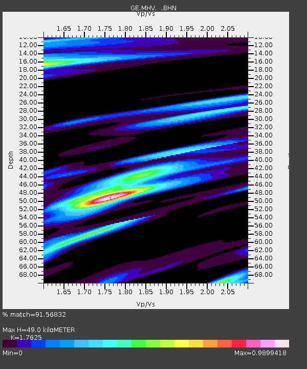
| Estimated Moho Depth: |
49.0 km |
| Estimated Crust Vp/Vs: |
1.76 |
| Assumed Crust Vp: |
6.516 km/s |
| Estimated Crust Vs: |
3.697 km/s |
| Estimated Crust Poisson's Ratio: |
0.26 |
|
| Radial Match: |
91.56832 % |
| Radial Bump: |
340 |
| Transverse Match: |
81.29123 % |
| Transverse Bump: |
400 |
| SOD ConfigId: |
4480 |
| Insert Time: |
2010-03-09 06:31:47.856 +0000 |
| GWidth: |
2.5 |
| Max Bumps: |
400 |
| Tol: |
0.001 |
|

Signal To Noise
| Channel | StoN | STA | LTA |
| GE:MHV: :BHN:19980709T05:27:03.310986Z | 8.438742 | 9.817102E-7 | 1.1633371E-7 |
| GE:MHV: :BHE:19980709T05:27:03.310986Z | 1.1582453 | 9.889143E-8 | 8.538038E-8 |
| GE:MHV: :BHZ:19980709T05:27:03.310986Z | 6.557857 | 4.2436056E-7 | 6.471025E-8 |
| Arrivals |
| Ps | 6.1 SECOND |
| PpPs | 19 SECOND |
| PsPs/PpSs | 26 SECOND |


