You are here: Home > Network List > OH - Ohio Seismic Network Stations List
> Station SROH Shade River SF > Earthquake Result Viewer
SROH Shade River SF - Earthquake Result Viewer
| Earthquake location: |
Off East Coast Of Kamchatka |
| Earthquake latitude/longitude: |
54.7/163.2 |
| Earthquake time(UTC): |
2021/03/16 (075) 18:38:22 GMT |
| Earthquake Depth: |
22 km |
| Earthquake Magnitude: |
6.6 mww |
| Earthquake Catalog/Contributor: |
NEIC PDE/us |
|
| Network: |
OH Ohio Seismic Network |
| Station: |
SROH Shade River SF |
| Lat/Lon: |
39.13 N/81.79 W |
| Elevation: |
263 m |
|
| Distance: |
71.3 deg |
| Az: |
48.1 deg |
| Baz: |
326.261 deg |
| Ray Param: |
0.054413863 |
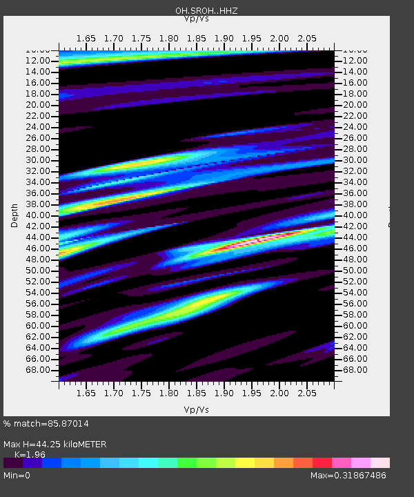
| Estimated Moho Depth: |
44.25 km |
| Estimated Crust Vp/Vs: |
1.96 |
| Assumed Crust Vp: |
6.207 km/s |
| Estimated Crust Vs: |
3.167 km/s |
| Estimated Crust Poisson's Ratio: |
0.32 |
|
| Radial Match: |
85.87014 % |
| Radial Bump: |
389 |
| Transverse Match: |
85.88082 % |
| Transverse Bump: |
399 |
| SOD ConfigId: |
24334971 |
| Insert Time: |
2021-03-30 18:58:21.382 +0000 |
| GWidth: |
2.5 |
| Max Bumps: |
400 |
| Tol: |
0.001 |
|

Signal To Noise
| Channel | StoN | STA | LTA |
| OH:SROH: :HHZ:20210316T18:49:09.285006Z | 2.1037827 | 2.1270955E-8 | 1.01108135E-8 |
| $trig.getChannelId() | $trig.getValue() | $trig.getSTA() | $trig.getLTA() |
| OH:SROH: :HHE:20210316T18:49:09.285006Z | 1.4772193 | 1.1443853E-8 | 7.7468885E-9 |
| Arrivals |
| Ps | 7.1 SECOND |
| PpPs | 20 SECOND |
| PsPs/PpSs | 28 SECOND |


