You are here: Home > Network List > GE - GEOFON Stations List
> Station MHV GEOFON Station Michnevo, Russia > Earthquake Result Viewer
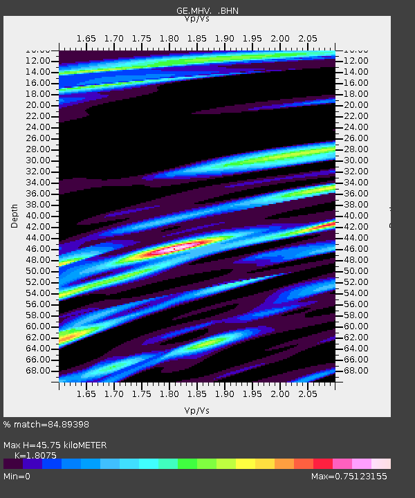
MHV GEOFON Station Michnevo, Russia - Earthquake Result Viewer
| Earthquake location: |
Northern Molucca Sea |
| Earthquake latitude/longitude: |
1.3/126.2 |
| Earthquake time(UTC): |
1998/12/06 (340) 00:47:13 GMT |
| Earthquake Depth: |
33 km |
| Earthquake Magnitude: |
6.3 MB, 6.2 MS, 6.6 UNKNOWN, 6.5 ME |
| Earthquake Catalog/Contributor: |
WHDF/NEIC |
|
| Network: |
GE GEOFON |
| Station: |
MHV GEOFON Station Michnevo, Russia |
| Lat/Lon: |
54.96 N/37.77 E |
| Elevation: |
150 m |
|
| Distance: |
88.1 deg |
| Az: |
324.771 deg |
| Baz: |
90.563 deg |
| Ray Param: |
0.04281106 |
| Estimated Moho Depth: |
45.75 km |
| Estimated Crust Vp/Vs: |
1.81 |
| Assumed Crust Vp: |
6.516 km/s |
| Estimated Crust Vs: |
3.605 km/s |
| Estimated Crust Poisson's Ratio: |
0.28 |
|
| Radial Match: |
84.89398 % |
| Radial Bump: |
400 |
| Transverse Match: |
87.090576 % |
| Transverse Bump: |
400 |
| SOD ConfigId: |
4480 |
| Insert Time: |
2010-03-09 06:32:14.529 +0000 |
| GWidth: |
2.5 |
| Max Bumps: |
400 |
| Tol: |
0.001 |
|

Signal To Noise
| Channel | StoN | STA | LTA |
| GE:MHV: :BHN:19981206T00:59:29.303015Z | 13.35256 | 2.5130037E-6 | 1.882039E-7 |
| GE:MHV: :BHE:19981206T00:59:29.303015Z | 1.4248064 | 3.007674E-7 | 2.1109351E-7 |
| GE:MHV: :BHZ:19981206T00:59:29.303015Z | 4.1086993 | 8.442249E-7 | 2.0547253E-7 |
| Arrivals |
| Ps | 5.8 SECOND |
| PpPs | 19 SECOND |
| PsPs/PpSs | 25 SECOND |


