You are here: Home > Network List > TA - USArray Transportable Network (new EarthScope stations) Stations List
> Station M31M Drury Creek, Yukon, CA > Earthquake Result Viewer
M31M Drury Creek, Yukon, CA - Earthquake Result Viewer
| Earthquake location: |
Off East Coast Of Kamchatka |
| Earthquake latitude/longitude: |
54.7/163.2 |
| Earthquake time(UTC): |
2021/03/16 (075) 18:38:22 GMT |
| Earthquake Depth: |
22 km |
| Earthquake Magnitude: |
6.6 mww |
| Earthquake Catalog/Contributor: |
NEIC PDE/us |
|
| Network: |
TA USArray Transportable Network (new EarthScope stations) |
| Station: |
M31M Drury Creek, Yukon, CA |
| Lat/Lon: |
62.20 N/134.39 W |
| Elevation: |
639 m |
|
| Distance: |
32.3 deg |
| Az: |
51.051 deg |
| Baz: |
285.665 deg |
| Ray Param: |
0.07870511 |
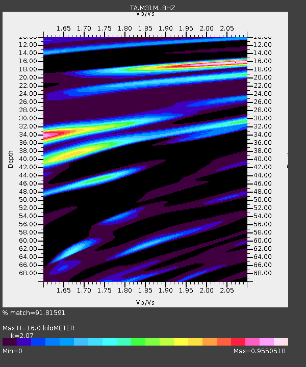
| Estimated Moho Depth: |
16.0 km |
| Estimated Crust Vp/Vs: |
2.07 |
| Assumed Crust Vp: |
6.419 km/s |
| Estimated Crust Vs: |
3.101 km/s |
| Estimated Crust Poisson's Ratio: |
0.35 |
|
| Radial Match: |
91.81591 % |
| Radial Bump: |
400 |
| Transverse Match: |
83.600525 % |
| Transverse Bump: |
400 |
| SOD ConfigId: |
24334971 |
| Insert Time: |
2021-03-30 19:02:12.583 +0000 |
| GWidth: |
2.5 |
| Max Bumps: |
400 |
| Tol: |
0.001 |
|
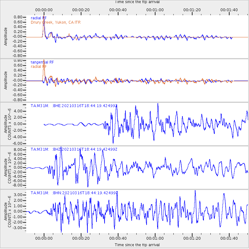
Signal To Noise
| Channel | StoN | STA | LTA |
| TA:M31M: :BHZ:20210316T18:44:19.42499Z | 4.1080904 | 1.1233403E-6 | 2.734459E-7 |
| TA:M31M: :BHN:20210316T18:44:19.42499Z | 1.3608814 | 3.3454072E-7 | 2.458265E-7 |
| TA:M31M: :BHE:20210316T18:44:19.42499Z | 2.3957245 | 5.613142E-7 | 2.3429833E-7 |
| Arrivals |
| Ps | 2.9 SECOND |
| PpPs | 7.2 SECOND |
| PsPs/PpSs | 10 SECOND |


