You are here: Home > Network List > GE - GEOFON Stations List
> Station MHV GEOFON Station Michnevo, Russia > Earthquake Result Viewer
MHV GEOFON Station Michnevo, Russia - Earthquake Result Viewer
| Earthquake location: |
Mid-Indian Ridge |
| Earthquake latitude/longitude: |
-26.5/74.5 |
| Earthquake time(UTC): |
1999/01/24 (024) 08:00:08 GMT |
| Earthquake Depth: |
10 km |
| Earthquake Magnitude: |
6.0 MB, 6.3 MS, 6.3 MW, 6.3 ME |
| Earthquake Catalog/Contributor: |
WHDF/NEIC |
|
| Network: |
GE GEOFON |
| Station: |
MHV GEOFON Station Michnevo, Russia |
| Lat/Lon: |
54.96 N/37.77 E |
| Elevation: |
150 m |
|
| Distance: |
87.0 deg |
| Az: |
339.804 deg |
| Baz: |
147.549 deg |
| Ray Param: |
0.043643206 |
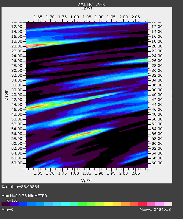
| Estimated Moho Depth: |
19.75 km |
| Estimated Crust Vp/Vs: |
1.60 |
| Assumed Crust Vp: |
6.516 km/s |
| Estimated Crust Vs: |
4.073 km/s |
| Estimated Crust Poisson's Ratio: |
0.18 |
|
| Radial Match: |
88.05884 % |
| Radial Bump: |
400 |
| Transverse Match: |
62.333134 % |
| Transverse Bump: |
400 |
| SOD ConfigId: |
4480 |
| Insert Time: |
2010-03-09 06:32:20.799 +0000 |
| GWidth: |
2.5 |
| Max Bumps: |
400 |
| Tol: |
0.001 |
|

Signal To Noise
| Channel | StoN | STA | LTA |
| GE:MHV: :BHN:19990124T08:12:22.391013Z | 8.480778 | 2.3238172E-6 | 2.7400992E-7 |
| GE:MHV: :BHE:19990124T08:12:22.391013Z | 1.9915379 | 5.100759E-7 | 2.561216E-7 |
| GE:MHV: :BHZ:19990124T08:12:22.391013Z | 0.8677542 | 2.8740348E-7 | 3.3120378E-7 |
| Arrivals |
| Ps | 1.9 SECOND |
| PpPs | 7.7 SECOND |
| PsPs/PpSs | 9.5 SECOND |


