You are here: Home > Network List > TX - Texas Seismological Network Stations List
> Station DRZT Darrouzett > Earthquake Result Viewer
DRZT Darrouzett - Earthquake Result Viewer
| Earthquake location: |
Off East Coast Of Kamchatka |
| Earthquake latitude/longitude: |
54.7/163.2 |
| Earthquake time(UTC): |
2021/03/16 (075) 18:38:22 GMT |
| Earthquake Depth: |
22 km |
| Earthquake Magnitude: |
6.6 mww |
| Earthquake Catalog/Contributor: |
NEIC PDE/us |
|
| Network: |
TX Texas Seismological Network |
| Station: |
DRZT Darrouzett |
| Lat/Lon: |
36.44 N/100.30 W |
| Elevation: |
791 m |
|
| Distance: |
64.6 deg |
| Az: |
62.471 deg |
| Baz: |
320.333 deg |
| Ray Param: |
0.058785994 |
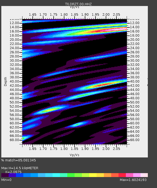
| Estimated Moho Depth: |
14.5 km |
| Estimated Crust Vp/Vs: |
2.10 |
| Assumed Crust Vp: |
6.483 km/s |
| Estimated Crust Vs: |
3.091 km/s |
| Estimated Crust Poisson's Ratio: |
0.35 |
|
| Radial Match: |
85.081345 % |
| Radial Bump: |
400 |
| Transverse Match: |
75.281425 % |
| Transverse Bump: |
400 |
| SOD ConfigId: |
24334971 |
| Insert Time: |
2021-03-30 19:03:06.793 +0000 |
| GWidth: |
2.5 |
| Max Bumps: |
400 |
| Tol: |
0.001 |
|

Signal To Noise
| Channel | StoN | STA | LTA |
| TX:DRZT:00:HHZ:20210316T18:48:27.499972Z | 3.1524282 | 8.880981E-7 | 2.8171874E-7 |
| TX:DRZT:00:HH1:20210316T18:48:27.499972Z | 0.6780777 | 2.324847E-7 | 3.428585E-7 |
| TX:DRZT:00:HH2:20210316T18:48:27.499972Z | 2.072388 | 3.7495155E-7 | 1.809273E-7 |
| Arrivals |
| Ps | 2.5 SECOND |
| PpPs | 6.7 SECOND |
| PsPs/PpSs | 9.2 SECOND |


