You are here: Home > Network List > TX - Texas Seismological Network Stations List
> Station ET01 Chireno > Earthquake Result Viewer
ET01 Chireno - Earthquake Result Viewer
| Earthquake location: |
Off East Coast Of Kamchatka |
| Earthquake latitude/longitude: |
54.7/163.2 |
| Earthquake time(UTC): |
2021/03/16 (075) 18:38:22 GMT |
| Earthquake Depth: |
22 km |
| Earthquake Magnitude: |
6.6 mww |
| Earthquake Catalog/Contributor: |
NEIC PDE/us |
|
| Network: |
TX Texas Seismological Network |
| Station: |
ET01 Chireno |
| Lat/Lon: |
31.46 N/94.37 W |
| Elevation: |
127 m |
|
| Distance: |
71.6 deg |
| Az: |
61.599 deg |
| Baz: |
323.31 deg |
| Ray Param: |
0.05423048 |
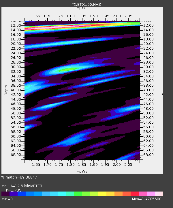
| Estimated Moho Depth: |
12.5 km |
| Estimated Crust Vp/Vs: |
1.74 |
| Assumed Crust Vp: |
5.738 km/s |
| Estimated Crust Vs: |
3.307 km/s |
| Estimated Crust Poisson's Ratio: |
0.25 |
|
| Radial Match: |
89.38847 % |
| Radial Bump: |
400 |
| Transverse Match: |
77.31343 % |
| Transverse Bump: |
400 |
| SOD ConfigId: |
24334971 |
| Insert Time: |
2021-03-30 19:03:10.762 +0000 |
| GWidth: |
2.5 |
| Max Bumps: |
400 |
| Tol: |
0.001 |
|

Signal To Noise
| Channel | StoN | STA | LTA |
| TX:ET01:00:HHZ:20210316T18:49:11.009982Z | 2.0039654 | 5.304033E-7 | 2.6467688E-7 |
| TX:ET01:00:HH1:20210316T18:49:11.009982Z | 0.79219335 | 2.177512E-7 | 2.7487127E-7 |
| TX:ET01:00:HH2:20210316T18:49:11.009982Z | 1.3096251 | 3.8560498E-7 | 2.944392E-7 |
| Arrivals |
| Ps | 1.6 SECOND |
| PpPs | 5.8 SECOND |
| PsPs/PpSs | 7.4 SECOND |


