You are here: Home > Network List > TX - Texas Seismological Network Stations List
> Station RTBA Rita Blanca > Earthquake Result Viewer
RTBA Rita Blanca - Earthquake Result Viewer
| Earthquake location: |
Off East Coast Of Kamchatka |
| Earthquake latitude/longitude: |
54.7/163.2 |
| Earthquake time(UTC): |
2021/03/16 (075) 18:38:22 GMT |
| Earthquake Depth: |
22 km |
| Earthquake Magnitude: |
6.6 mww |
| Earthquake Catalog/Contributor: |
NEIC PDE/us |
|
| Network: |
TX Texas Seismological Network |
| Station: |
RTBA Rita Blanca |
| Lat/Lon: |
36.44 N/102.74 W |
| Elevation: |
1284 m |
|
| Distance: |
63.4 deg |
| Az: |
64.153 deg |
| Baz: |
319.627 deg |
| Ray Param: |
0.05960992 |
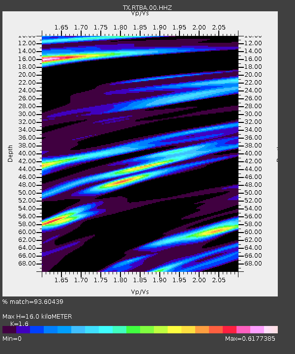
| Estimated Moho Depth: |
16.0 km |
| Estimated Crust Vp/Vs: |
1.60 |
| Assumed Crust Vp: |
6.306 km/s |
| Estimated Crust Vs: |
3.941 km/s |
| Estimated Crust Poisson's Ratio: |
0.18 |
|
| Radial Match: |
93.60439 % |
| Radial Bump: |
278 |
| Transverse Match: |
78.30325 % |
| Transverse Bump: |
334 |
| SOD ConfigId: |
24334971 |
| Insert Time: |
2021-03-30 19:03:46.707 +0000 |
| GWidth: |
2.5 |
| Max Bumps: |
400 |
| Tol: |
0.001 |
|

Signal To Noise
| Channel | StoN | STA | LTA |
| TX:RTBA:00:HHZ:20210316T18:48:19.230014Z | 2.1398678 | 4.0150917E-7 | 1.876327E-7 |
| TX:RTBA:00:HH1:20210316T18:48:19.230014Z | 1.3065435 | 3.6271788E-7 | 2.776164E-7 |
| TX:RTBA:00:HH2:20210316T18:48:19.230014Z | 0.39535677 | 1.2422866E-7 | 3.1421914E-7 |
| Arrivals |
| Ps | 1.6 SECOND |
| PpPs | 6.3 SECOND |
| PsPs/PpSs | 7.9 SECOND |


