You are here: Home > Network List > GE - GEOFON Stations List
> Station MHV GEOFON Station Michnevo, Russia > Earthquake Result Viewer
MHV GEOFON Station Michnevo, Russia - Earthquake Result Viewer
| Earthquake location: |
Laptev Sea |
| Earthquake latitude/longitude: |
75.8/134.6 |
| Earthquake time(UTC): |
1996/06/22 (174) 16:47:12 GMT |
| Earthquake Depth: |
10 km |
| Earthquake Magnitude: |
5.6 MB, 5.5 MS, 5.8 UNKNOWN, 5.7 MW |
| Earthquake Catalog/Contributor: |
WHDF/NEIC |
|
| Network: |
GE GEOFON |
| Station: |
MHV GEOFON Station Michnevo, Russia |
| Lat/Lon: |
54.96 N/37.77 E |
| Elevation: |
150 m |
|
| Distance: |
39.2 deg |
| Az: |
295.087 deg |
| Baz: |
22.775 deg |
| Ray Param: |
0.075111605 |
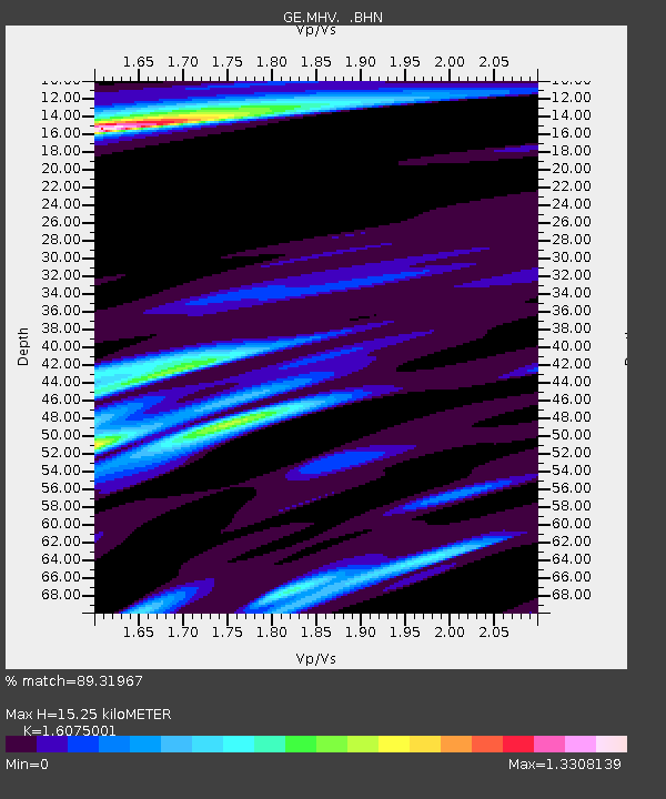
| Estimated Moho Depth: |
15.25 km |
| Estimated Crust Vp/Vs: |
1.61 |
| Assumed Crust Vp: |
6.516 km/s |
| Estimated Crust Vs: |
4.054 km/s |
| Estimated Crust Poisson's Ratio: |
0.18 |
|
| Radial Match: |
89.31967 % |
| Radial Bump: |
383 |
| Transverse Match: |
70.736725 % |
| Transverse Bump: |
400 |
| SOD ConfigId: |
4480 |
| Insert Time: |
2010-03-09 06:32:25.062 +0000 |
| GWidth: |
2.5 |
| Max Bumps: |
400 |
| Tol: |
0.001 |
|

Signal To Noise
| Channel | StoN | STA | LTA |
| GE:MHV: :BHN:19960622T16:54:10.363989Z | 7.8478937 | 1.2172219E-6 | 1.5510173E-7 |
| GE:MHV: :BHE:19960622T16:54:10.363989Z | 3.1951964 | 5.992493E-7 | 1.8754695E-7 |
| GE:MHV: :BHZ:19960622T16:54:10.363989Z | 2.0869825 | 2.721226E-7 | 1.3039046E-7 |
| Arrivals |
| Ps | 1.5 SECOND |
| PpPs | 5.6 SECOND |
| PsPs/PpSs | 7.2 SECOND |


