You are here: Home > Network List > US - United States National Seismic Network Stations List
> Station AMTX Amarillo, Texas, USA > Earthquake Result Viewer
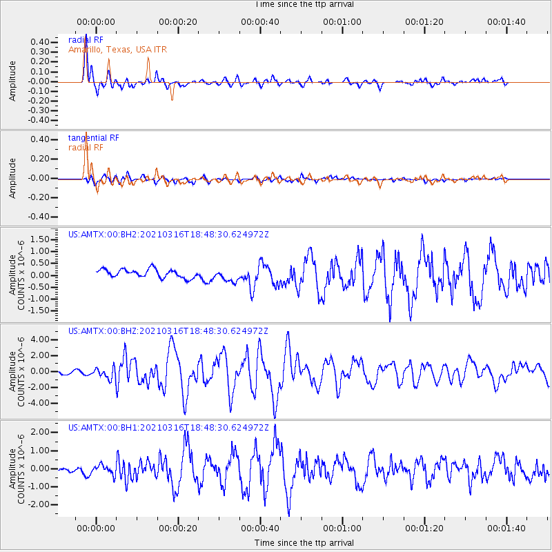
AMTX Amarillo, Texas, USA - Earthquake Result Viewer
*The percent match for this event was below the threshold and hence no stack was calculated.
| Earthquake location: |
Off East Coast Of Kamchatka |
| Earthquake latitude/longitude: |
54.7/163.2 |
| Earthquake time(UTC): |
2021/03/16 (075) 18:38:22 GMT |
| Earthquake Depth: |
22 km |
| Earthquake Magnitude: |
6.6 mww |
| Earthquake Catalog/Contributor: |
NEIC PDE/us |
|
| Network: |
US United States National Seismic Network |
| Station: |
AMTX Amarillo, Texas, USA |
| Lat/Lon: |
34.53 N/101.41 W |
| Elevation: |
1010 m |
|
| Distance: |
65.5 deg |
| Az: |
64.583 deg |
| Baz: |
320.581 deg |
| Ray Param: |
$rayparam |
*The percent match for this event was below the threshold and hence was not used in the summary stack. |
|
| Radial Match: |
94.18759 % |
| Radial Bump: |
357 |
| Transverse Match: |
64.36864 % |
| Transverse Bump: |
400 |
| SOD ConfigId: |
24334971 |
| Insert Time: |
2021-03-30 19:04:37.927 +0000 |
| GWidth: |
2.5 |
| Max Bumps: |
400 |
| Tol: |
0.001 |
|
Signal To Noise
| Channel | StoN | STA | LTA |
| US:AMTX:00:BHZ:20210316T18:48:30.624972Z | 3.6711576 | 7.127232E-7 | 1.9414126E-7 |
| US:AMTX:00:BH1:20210316T18:48:30.624972Z | 1.4389673 | 2.556911E-7 | 1.776907E-7 |
| US:AMTX:00:BH2:20210316T18:48:30.624972Z | 1.3687932 | 2.5990573E-7 | 1.8987947E-7 |
| Arrivals |
| Ps | |
| PpPs | |
| PsPs/PpSs | |


