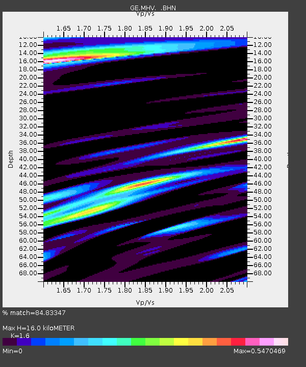
MHV GEOFON Station Michnevo, Russia - Earthquake Result Viewer

Earthquake location: Southwestern Ryukyu Isl., Japan
Earthquake latitude/longitude: 23.3/124.2
Earthquake time(UTC): 2000/11/08 (313) 18:36:21 GMT
Earthquake Depth: 14 km
Earthquake Magnitude: 5.7 MB, 5.5 MS, 5.8 MW, 5.6 MW
Earthquake Catalog/Contributor: WHDF/NEIC
Network: GE GEOFON
Station: MHV GEOFON Station Michnevo, Russia
Lat/Lon: 54.96 N/37.77 E
Elevation: 150 m
Distance: 69.3 deg
Az: 322.013 deg
Baz: 78.966 deg
Ray Param: 0.05575635
Estimated Moho Depth: 16.0 km
Estimated Crust Vp/Vs: 1.60
Assumed Crust Vp: 6.516 km/s
Estimated Crust Vs: 4.073 km/s
Estimated Crust Poisson's Ratio: 0.18
Radial Match: 84.83347 %
Radial Bump: 343
Transverse Match: 59.32802 %
Transverse Bump: 400
SOD ConfigId: 3753
Insert Time: 2010-03-09 06:32:31.333 +0000
GWidth: 2.5
Max Bumps: 400
Tol: 0.001

Signal To Noise

ChannelStoNSTALTA
GE:MHV: :BHN:20001108T18:46:56.866016Z0.97054491.5934438E-71.6418034E-7
GE:MHV: :BHE:20001108T18:46:56.866016Z1.91212673.023623E-71.5812881E-7
GE:MHV: :BHZ:20001108T18:46:56.866016Z4.17663577.40352E-71.7726036E-7
Arrivals
Ps1.5 SECOND
PpPs6.1 SECOND
PsPs/PpSs7.7 SECOND