You are here: Home > Network List > GE - GEOFON Stations List
> Station MHV GEOFON Station Michnevo, Russia > Earthquake Result Viewer
MHV GEOFON Station Michnevo, Russia - Earthquake Result Viewer
| Earthquake location: |
Banda Sea |
| Earthquake latitude/longitude: |
-4.2/127.3 |
| Earthquake time(UTC): |
2000/08/28 (241) 19:29:24 GMT |
| Earthquake Depth: |
33 km |
| Earthquake Magnitude: |
6.0 MB |
| Earthquake Catalog/Contributor: |
WHDF/NEIC |
|
| Network: |
GE GEOFON |
| Station: |
MHV GEOFON Station Michnevo, Russia |
| Lat/Lon: |
54.96 N/37.77 E |
| Elevation: |
150 m |
|
| Distance: |
93.1 deg |
| Az: |
324.72 deg |
| Baz: |
92.759 deg |
| Ray Param: |
0.041313723 |
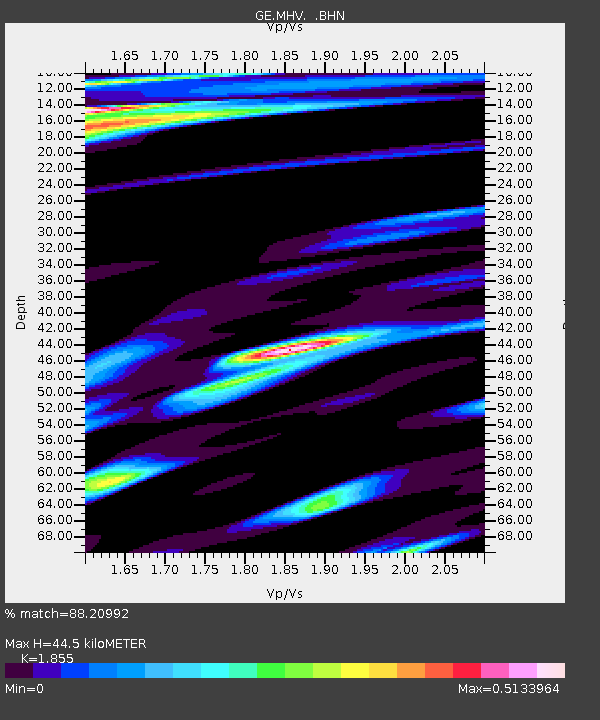
| Estimated Moho Depth: |
44.5 km |
| Estimated Crust Vp/Vs: |
1.86 |
| Assumed Crust Vp: |
6.516 km/s |
| Estimated Crust Vs: |
3.513 km/s |
| Estimated Crust Poisson's Ratio: |
0.30 |
|
| Radial Match: |
88.20992 % |
| Radial Bump: |
400 |
| Transverse Match: |
88.62102 % |
| Transverse Bump: |
400 |
| SOD ConfigId: |
3744 |
| Insert Time: |
2010-03-09 06:32:44.775 +0000 |
| GWidth: |
2.5 |
| Max Bumps: |
400 |
| Tol: |
0.001 |
|

Signal To Noise
| Channel | StoN | STA | LTA |
| GE:MHV: :BHN:20000828T19:42:03.817009Z | 0.79574794 | 5.483991E-8 | 6.891618E-8 |
| GE:MHV: :BHE:20000828T19:42:03.817009Z | 2.03232 | 1.7229706E-7 | 8.477851E-8 |
| GE:MHV: :BHZ:20000828T19:42:03.817009Z | 5.3831024 | 4.948865E-7 | 9.1933316E-8 |
| Arrivals |
| Ps | 6.0 SECOND |
| PpPs | 19 SECOND |
| PsPs/PpSs | 25 SECOND |


