You are here: Home > Network List > GE - GEOFON Stations List
> Station MHV GEOFON Station Michnevo, Russia > Earthquake Result Viewer
MHV GEOFON Station Michnevo, Russia - Earthquake Result Viewer
| Earthquake location: |
Taiwan Region |
| Earthquake latitude/longitude: |
24.0/122.7 |
| Earthquake time(UTC): |
2001/12/18 (352) 04:02:58 GMT |
| Earthquake Depth: |
14 km |
| Earthquake Magnitude: |
6.3 MB, 7.3 MS, 6.9 MW, 6.8 MW |
| Earthquake Catalog/Contributor: |
WHDF/NEIC |
|
| Network: |
GE GEOFON |
| Station: |
MHV GEOFON Station Michnevo, Russia |
| Lat/Lon: |
54.96 N/37.77 E |
| Elevation: |
150 m |
|
| Distance: |
67.9 deg |
| Az: |
321.681 deg |
| Baz: |
79.599 deg |
| Ray Param: |
0.05664218 |
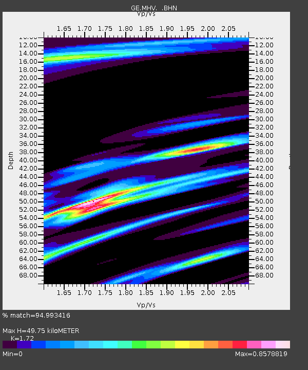
| Estimated Moho Depth: |
49.75 km |
| Estimated Crust Vp/Vs: |
1.72 |
| Assumed Crust Vp: |
6.516 km/s |
| Estimated Crust Vs: |
3.788 km/s |
| Estimated Crust Poisson's Ratio: |
0.24 |
|
| Radial Match: |
94.993416 % |
| Radial Bump: |
244 |
| Transverse Match: |
83.70909 % |
| Transverse Bump: |
400 |
| SOD ConfigId: |
20082 |
| Insert Time: |
2010-03-09 06:33:32.212 +0000 |
| GWidth: |
2.5 |
| Max Bumps: |
400 |
| Tol: |
0.001 |
|

Signal To Noise
| Channel | StoN | STA | LTA |
| GE:MHV: :BHN:20011218T04:13:25.097017Z | 1.1759413 | 6.105809E-7 | 5.1922734E-7 |
| GE:MHV: :BHE:20011218T04:13:25.097017Z | 5.585083 | 2.2598558E-6 | 4.046235E-7 |
| GE:MHV: :BHZ:20011218T04:13:25.097017Z | 9.244344 | 4.3923187E-6 | 4.7513583E-7 |
| Arrivals |
| Ps | 5.7 SECOND |
| PpPs | 20 SECOND |
| PsPs/PpSs | 26 SECOND |


