You are here: Home > Network List > IW - Intermountain West Stations List
> Station MOOW Moose Ponds, Wyoming, USA > Earthquake Result Viewer
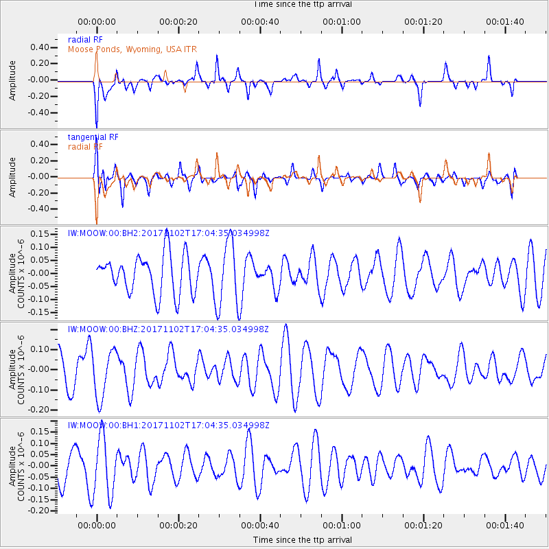
MOOW Moose Ponds, Wyoming, USA - Earthquake Result Viewer
*The percent match for this event was below the threshold and hence no stack was calculated.
| Earthquake location: |
Southeast Of Loyalty Islands |
| Earthquake latitude/longitude: |
-21.9/169.0 |
| Earthquake time(UTC): |
2017/11/02 (306) 16:51:29 GMT |
| Earthquake Depth: |
5.2 km |
| Earthquake Magnitude: |
5.4 Mww |
| Earthquake Catalog/Contributor: |
NEIC PDE/us |
|
| Network: |
IW Intermountain West |
| Station: |
MOOW Moose Ponds, Wyoming, USA |
| Lat/Lon: |
43.75 N/110.74 W |
| Elevation: |
2128 m |
|
| Distance: |
98.1 deg |
| Az: |
46.167 deg |
| Baz: |
247.624 deg |
| Ray Param: |
$rayparam |
*The percent match for this event was below the threshold and hence was not used in the summary stack. |
|
| Radial Match: |
67.62058 % |
| Radial Bump: |
400 |
| Transverse Match: |
50.002502 % |
| Transverse Bump: |
400 |
| SOD ConfigId: |
2429771 |
| Insert Time: |
2017-11-16 16:55:36.326 +0000 |
| GWidth: |
2.5 |
| Max Bumps: |
400 |
| Tol: |
0.001 |
|
Signal To Noise
| Channel | StoN | STA | LTA |
| IW:MOOW:00:BHZ:20171102T17:04:35.034998Z | 1.4788617 | 1.18866915E-7 | 8.0377305E-8 |
| IW:MOOW:00:BH1:20171102T17:04:35.034998Z | 1.6503708 | 1.2836891E-7 | 7.7781856E-8 |
| IW:MOOW:00:BH2:20171102T17:04:35.034998Z | 1.7360318 | 1.292619E-7 | 7.4458264E-8 |
| Arrivals |
| Ps | |
| PpPs | |
| PsPs/PpSs | |


