You are here: Home > Network List > GE - GEOFON Stations List
> Station MHV GEOFON Station Michnevo, Russia > Earthquake Result Viewer
MHV GEOFON Station Michnevo, Russia - Earthquake Result Viewer
| Earthquake location: |
North Indian Ocean |
| Earthquake latitude/longitude: |
0.9/82.5 |
| Earthquake time(UTC): |
2001/09/02 (245) 02:25:54 GMT |
| Earthquake Depth: |
10 km |
| Earthquake Magnitude: |
5.6 MB, 5.8 MS, 6.1 MW, 6.1 MW |
| Earthquake Catalog/Contributor: |
WHDF/NEIC |
|
| Network: |
GE GEOFON |
| Station: |
MHV GEOFON Station Michnevo, Russia |
| Lat/Lon: |
54.96 N/37.77 E |
| Elevation: |
150 m |
|
| Distance: |
65.0 deg |
| Az: |
333.397 deg |
| Baz: |
129.073 deg |
| Ray Param: |
0.05854397 |
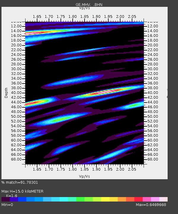
| Estimated Moho Depth: |
15.0 km |
| Estimated Crust Vp/Vs: |
1.60 |
| Assumed Crust Vp: |
6.516 km/s |
| Estimated Crust Vs: |
4.073 km/s |
| Estimated Crust Poisson's Ratio: |
0.18 |
|
| Radial Match: |
91.78301 % |
| Radial Bump: |
400 |
| Transverse Match: |
84.31235 % |
| Transverse Bump: |
400 |
| SOD ConfigId: |
20082 |
| Insert Time: |
2010-03-09 06:33:45.198 +0000 |
| GWidth: |
2.5 |
| Max Bumps: |
400 |
| Tol: |
0.001 |
|

Signal To Noise
| Channel | StoN | STA | LTA |
| GE:MHV: :BHN:20010902T02:36:03.147007Z | 1.5547287 | 1.1544933E-7 | 7.4256896E-8 |
| GE:MHV: :BHE:20010902T02:36:03.147007Z | 2.188406 | 1.5126726E-7 | 6.912212E-8 |
| GE:MHV: :BHZ:20010902T02:36:03.147007Z | 6.686148 | 7.774152E-7 | 1.1627251E-7 |
| Arrivals |
| Ps | 1.4 SECOND |
| PpPs | 5.7 SECOND |
| PsPs/PpSs | 7.2 SECOND |


