You are here: Home > Network List > GE - GEOFON Stations List
> Station MHV GEOFON Station Michnevo, Russia > Earthquake Result Viewer
MHV GEOFON Station Michnevo, Russia - Earthquake Result Viewer
| Earthquake location: |
Southern India |
| Earthquake latitude/longitude: |
23.4/70.2 |
| Earthquake time(UTC): |
2001/01/26 (026) 03:16:40 GMT |
| Earthquake Depth: |
16 km |
| Earthquake Magnitude: |
6.9 MB, 8.0 MS, 7.7 MW, 7.7 ME |
| Earthquake Catalog/Contributor: |
WHDF/NEIC |
|
| Network: |
GE GEOFON |
| Station: |
MHV GEOFON Station Michnevo, Russia |
| Lat/Lon: |
54.96 N/37.77 E |
| Elevation: |
150 m |
|
| Distance: |
39.7 deg |
| Az: |
330.982 deg |
| Baz: |
129.412 deg |
| Ray Param: |
0.07484147 |
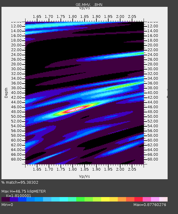
| Estimated Moho Depth: |
46.75 km |
| Estimated Crust Vp/Vs: |
1.81 |
| Assumed Crust Vp: |
6.516 km/s |
| Estimated Crust Vs: |
3.6 km/s |
| Estimated Crust Poisson's Ratio: |
0.28 |
|
| Radial Match: |
95.38302 % |
| Radial Bump: |
229 |
| Transverse Match: |
77.22438 % |
| Transverse Bump: |
400 |
| SOD ConfigId: |
3744 |
| Insert Time: |
2010-03-09 06:33:55.032 +0000 |
| GWidth: |
2.5 |
| Max Bumps: |
400 |
| Tol: |
0.001 |
|

Signal To Noise
| Channel | StoN | STA | LTA |
| GE:MHV: :BHN:20010126T03:23:40.733002Z | 4.0484185 | 1.6194472E-6 | 4.000197E-7 |
| GE:MHV: :BHE:20010126T03:23:40.733002Z | 4.4936547 | 2.280709E-6 | 5.075398E-7 |
| GE:MHV: :BHZ:20010126T03:23:40.733002Z | 13.707229 | 5.4977168E-6 | 4.0108156E-7 |
| Arrivals |
| Ps | 6.2 SECOND |
| PpPs | 19 SECOND |
| PsPs/PpSs | 25 SECOND |


