You are here: Home > Network List > ON - RSIS-Rede Sismografica do Sul e Sudeste Observatorio Nacional, Brazil Stations List
> Station GUA01 "OBSN: [GUA01] Guaratinga, BA" > Earthquake Result Viewer
GUA01 "OBSN: [GUA01] Guaratinga, BA" - Earthquake Result Viewer
| Earthquake location: |
Northern Algeria |
| Earthquake latitude/longitude: |
36.9/5.2 |
| Earthquake time(UTC): |
2021/03/18 (077) 00:04:06 GMT |
| Earthquake Depth: |
8.0 km |
| Earthquake Magnitude: |
6.0 mww |
| Earthquake Catalog/Contributor: |
NEIC PDE/us |
|
| Network: |
ON RSIS-Rede Sismografica do Sul e Sudeste Observatorio Nacional, Brazil |
| Station: |
GUA01 "OBSN: [GUA01] Guaratinga, BA" |
| Lat/Lon: |
16.58 S/39.81 W |
| Elevation: |
198 m |
|
| Distance: |
68.1 deg |
| Az: |
226.979 deg |
| Baz: |
37.666 deg |
| Ray Param: |
0.056562442 |
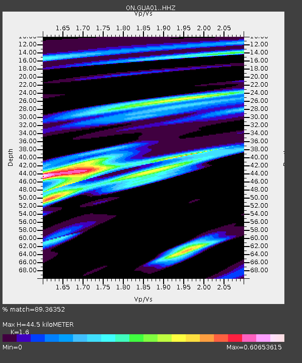
| Estimated Moho Depth: |
44.5 km |
| Estimated Crust Vp/Vs: |
1.60 |
| Assumed Crust Vp: |
6.391 km/s |
| Estimated Crust Vs: |
3.994 km/s |
| Estimated Crust Poisson's Ratio: |
0.18 |
|
| Radial Match: |
89.36352 % |
| Radial Bump: |
357 |
| Transverse Match: |
60.915443 % |
| Transverse Bump: |
400 |
| SOD ConfigId: |
24334971 |
| Insert Time: |
2021-04-01 00:18:47.287 +0000 |
| GWidth: |
2.5 |
| Max Bumps: |
400 |
| Tol: |
0.001 |
|

Signal To Noise
| Channel | StoN | STA | LTA |
| ON:GUA01: :HHZ:20210318T00:14:35.488002Z | 3.5199225 | 4.1930107E-7 | 1.1912224E-7 |
| ON:GUA01: :HHN:20210318T00:14:35.488002Z | 1.8894027 | 1.7940162E-7 | 9.4951496E-8 |
| ON:GUA01: :HHE:20210318T00:14:35.488002Z | 1.0478662 | 1.1971044E-7 | 1.14242106E-7 |
| Arrivals |
| Ps | 4.4 SECOND |
| PpPs | 17 SECOND |
| PsPs/PpSs | 22 SECOND |


