You are here: Home > Network List > GE - GEOFON Stations List
> Station MHV GEOFON Station Michnevo, Russia > Earthquake Result Viewer
MHV GEOFON Station Michnevo, Russia - Earthquake Result Viewer
| Earthquake location: |
Banda Sea |
| Earthquake latitude/longitude: |
-4.0/128.0 |
| Earthquake time(UTC): |
2001/03/19 (078) 05:52:15 GMT |
| Earthquake Depth: |
33 km |
| Earthquake Magnitude: |
6.0 MB, 6.5 MS, 6.5 MW, 6.5 MW |
| Earthquake Catalog/Contributor: |
WHDF/NEIC |
|
| Network: |
GE GEOFON |
| Station: |
MHV GEOFON Station Michnevo, Russia |
| Lat/Lon: |
54.96 N/37.77 E |
| Elevation: |
150 m |
|
| Distance: |
93.4 deg |
| Az: |
324.707 deg |
| Baz: |
92.104 deg |
| Ray Param: |
0.041254435 |
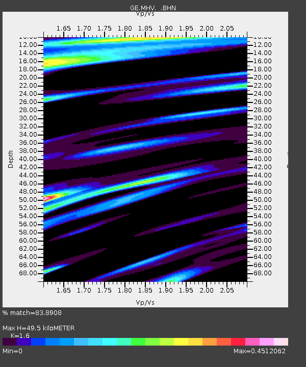
| Estimated Moho Depth: |
49.5 km |
| Estimated Crust Vp/Vs: |
1.60 |
| Assumed Crust Vp: |
6.516 km/s |
| Estimated Crust Vs: |
4.073 km/s |
| Estimated Crust Poisson's Ratio: |
0.18 |
|
| Radial Match: |
83.8908 % |
| Radial Bump: |
398 |
| Transverse Match: |
66.8721 % |
| Transverse Bump: |
400 |
| SOD ConfigId: |
4714 |
| Insert Time: |
2010-03-09 06:34:08.697 +0000 |
| GWidth: |
2.5 |
| Max Bumps: |
400 |
| Tol: |
0.001 |
|

Signal To Noise
| Channel | StoN | STA | LTA |
| GE:MHV: :BHN:20010319T06:04:56.494004Z | 0.9002593 | 1.11807935E-7 | 1.2419525E-7 |
| GE:MHV: :BHE:20010319T06:04:56.494004Z | 1.3362627 | 1.5967667E-7 | 1.1949497E-7 |
| GE:MHV: :BHZ:20010319T06:04:56.494004Z | 2.4090605 | 2.4823765E-7 | 1.0304334E-7 |
| Arrivals |
| Ps | 4.7 SECOND |
| PpPs | 19 SECOND |
| PsPs/PpSs | 24 SECOND |


