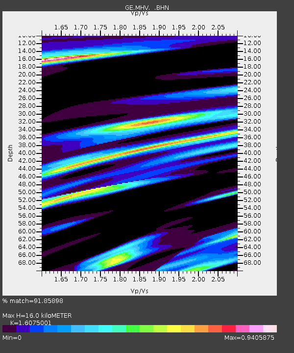
MHV GEOFON Station Michnevo, Russia - Earthquake Result Viewer

Earthquake location: Southern Yukon Territory, Canada
Earthquake latitude/longitude: 61.3/-140.1
Earthquake time(UTC): 2001/06/26 (177) 14:05:37 GMT
Earthquake Depth: 10 km
Earthquake Magnitude: 5.8 MB, 5.4 MS, 6.0 ML, 5.8 MW
Earthquake Catalog/Contributor: WHDF/NEIC
Network: GE GEOFON
Station: MHV GEOFON Station Michnevo, Russia
Lat/Lon: 54.96 N/37.77 E
Elevation: 150 m
Distance: 64.0 deg
Az: 1.388 deg
Baz: 358.84 deg
Ray Param: 0.059187584
Estimated Moho Depth: 16.0 km
Estimated Crust Vp/Vs: 1.61
Assumed Crust Vp: 6.516 km/s
Estimated Crust Vs: 4.054 km/s
Estimated Crust Poisson's Ratio: 0.18
Radial Match: 91.85898 %
Radial Bump: 400
Transverse Match: 79.0154 %
Transverse Bump: 400
SOD ConfigId: 4714
Insert Time: 2010-03-09 06:34:21.092 +0000
GWidth: 2.5
Max Bumps: 400
Tol: 0.001

Signal To Noise

ChannelStoNSTALTA
GE:MHV: :BHN:20010626T14:15:39.593994Z8.0372846.5200805E-78.1122934E-8
GE:MHV: :BHE:20010626T14:15:39.593994Z1.81694751.2282207E-76.759803E-8
GE:MHV: :BHZ:20010626T14:15:39.593994Z10.7093781.2178541E-61.1371847E-7
Arrivals
Ps1.6 SECOND
PpPs6.1 SECOND
PsPs/PpSs7.7 SECOND