You are here: Home > Network List > GE - GEOFON Stations List
> Station MHV GEOFON Station Michnevo, Russia > Earthquake Result Viewer
MHV GEOFON Station Michnevo, Russia - Earthquake Result Viewer
| Earthquake location: |
Taiwan Region |
| Earthquake latitude/longitude: |
24.5/122.0 |
| Earthquake time(UTC): |
2001/06/14 (165) 02:35:25 GMT |
| Earthquake Depth: |
32 km |
| Earthquake Magnitude: |
5.7 MB, 5.6 MS, 5.9 MW, 5.9 MW |
| Earthquake Catalog/Contributor: |
WHDF/NEIC |
|
| Network: |
GE GEOFON |
| Station: |
MHV GEOFON Station Michnevo, Russia |
| Lat/Lon: |
54.96 N/37.77 E |
| Elevation: |
150 m |
|
| Distance: |
67.1 deg |
| Az: |
321.459 deg |
| Baz: |
79.767 deg |
| Ray Param: |
0.05714448 |
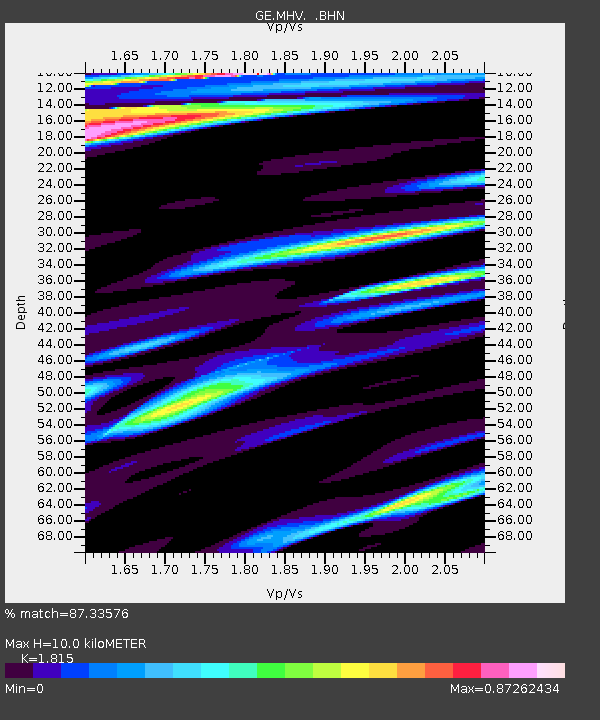
| Estimated Moho Depth: |
10.0 km |
| Estimated Crust Vp/Vs: |
1.82 |
| Assumed Crust Vp: |
6.516 km/s |
| Estimated Crust Vs: |
3.59 km/s |
| Estimated Crust Poisson's Ratio: |
0.28 |
|
| Radial Match: |
87.33576 % |
| Radial Bump: |
400 |
| Transverse Match: |
79.78057 % |
| Transverse Bump: |
400 |
| SOD ConfigId: |
3753 |
| Insert Time: |
2010-03-09 06:34:24.971 +0000 |
| GWidth: |
2.5 |
| Max Bumps: |
400 |
| Tol: |
0.001 |
|

Signal To Noise
| Channel | StoN | STA | LTA |
| GE:MHV: :BHN:20010614T02:45:45.093997Z | 1.5095416 | 1.8437535E-7 | 1.2213997E-7 |
| GE:MHV: :BHE:20010614T02:45:45.093997Z | 6.4311495 | 4.3642052E-7 | 6.786042E-8 |
| GE:MHV: :BHZ:20010614T02:45:45.093997Z | 9.4771805 | 8.960433E-7 | 9.4547445E-8 |
| Arrivals |
| Ps | 1.3 SECOND |
| PpPs | 4.2 SECOND |
| PsPs/PpSs | 5.5 SECOND |


