You are here: Home > Network List > GE - GEOFON Stations List
> Station MHV GEOFON Station Michnevo, Russia > Earthquake Result Viewer
MHV GEOFON Station Michnevo, Russia - Earthquake Result Viewer
| Earthquake location: |
Sunda Strait, Indonesia |
| Earthquake latitude/longitude: |
-7.0/104.2 |
| Earthquake time(UTC): |
2002/06/27 (178) 05:50:35 GMT |
| Earthquake Depth: |
11 km |
| Earthquake Magnitude: |
6.0 MB, 6.9 MS, 6.6 MW, 6.5 MW |
| Earthquake Catalog/Contributor: |
WHDF/NEIC |
|
| Network: |
GE GEOFON |
| Station: |
MHV GEOFON Station Michnevo, Russia |
| Lat/Lon: |
54.96 N/37.77 E |
| Elevation: |
150 m |
|
| Distance: |
82.5 deg |
| Az: |
327.782 deg |
| Baz: |
113.413 deg |
| Ray Param: |
0.046849567 |
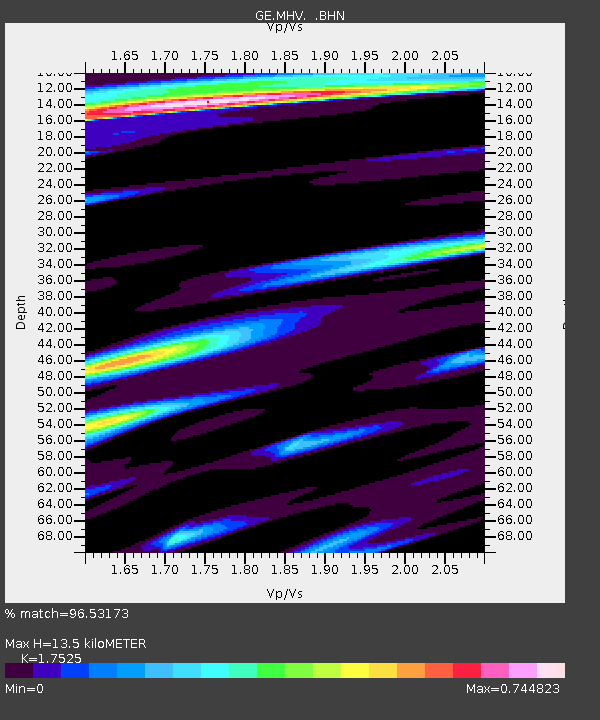
| Estimated Moho Depth: |
13.5 km |
| Estimated Crust Vp/Vs: |
1.75 |
| Assumed Crust Vp: |
6.516 km/s |
| Estimated Crust Vs: |
3.718 km/s |
| Estimated Crust Poisson's Ratio: |
0.26 |
|
| Radial Match: |
96.53173 % |
| Radial Bump: |
320 |
| Transverse Match: |
96.10269 % |
| Transverse Bump: |
385 |
| SOD ConfigId: |
20082 |
| Insert Time: |
2010-03-09 06:34:41.550 +0000 |
| GWidth: |
2.5 |
| Max Bumps: |
400 |
| Tol: |
0.001 |
|

Signal To Noise
| Channel | StoN | STA | LTA |
| GE:MHV: :BHN:20020627T06:02:26.146011Z | 1.2820607 | 2.0509216E-7 | 1.5997071E-7 |
| GE:MHV: :BHE:20020627T06:02:26.146011Z | 4.127016 | 5.976363E-7 | 1.4481076E-7 |
| GE:MHV: :BHZ:20020627T06:02:26.146011Z | 10.820521 | 1.8973998E-6 | 1.7535197E-7 |
| Arrivals |
| Ps | 1.6 SECOND |
| PpPs | 5.5 SECOND |
| PsPs/PpSs | 7.2 SECOND |


