You are here: Home > Network List > CI - Caltech Regional Seismic Network Stations List
> Station MPM Manuel Prospect Mine, California, USA > Earthquake Result Viewer
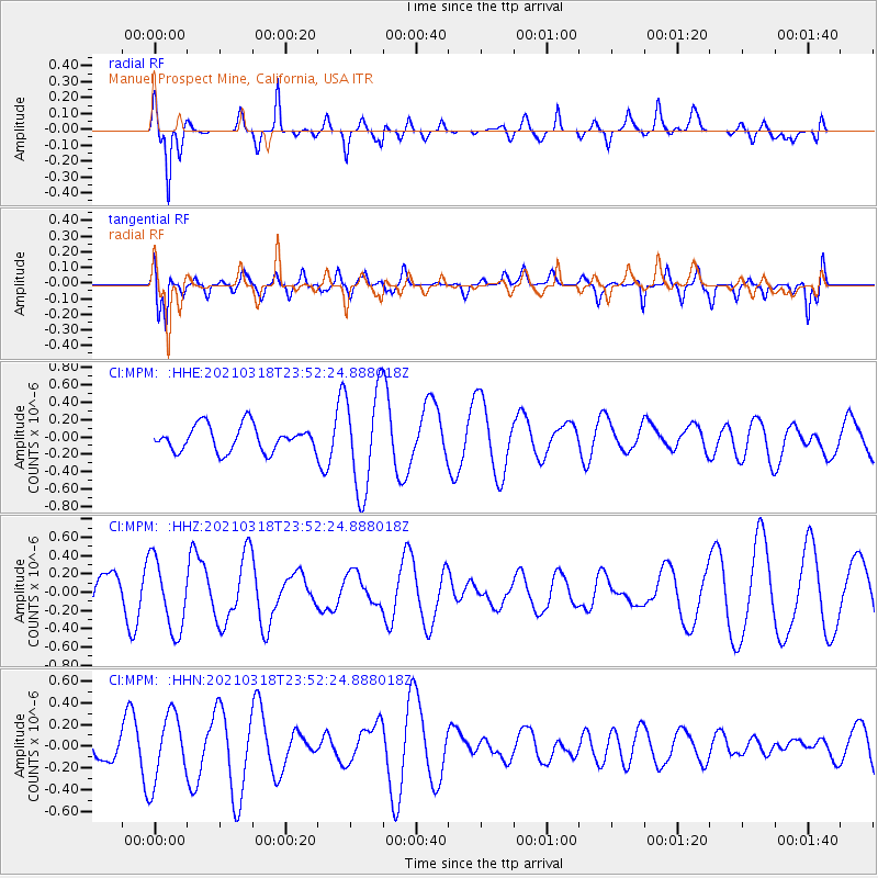
MPM Manuel Prospect Mine, California, USA - Earthquake Result Viewer
*The percent match for this event was below the threshold and hence no stack was calculated.
| Earthquake location: |
D'Entrecasteaux Islands Region |
| Earthquake latitude/longitude: |
-9.6/155.6 |
| Earthquake time(UTC): |
2021/03/18 (077) 23:39:41 GMT |
| Earthquake Depth: |
5.0 km |
| Earthquake Magnitude: |
5.5 Mww |
| Earthquake Catalog/Contributor: |
NEIC PDE/us |
|
| Network: |
CI Caltech Regional Seismic Network |
| Station: |
MPM Manuel Prospect Mine, California, USA |
| Lat/Lon: |
36.06 N/117.49 W |
| Elevation: |
185 m |
|
| Distance: |
93.1 deg |
| Az: |
54.126 deg |
| Baz: |
260.517 deg |
| Ray Param: |
$rayparam |
*The percent match for this event was below the threshold and hence was not used in the summary stack. |
|
| Radial Match: |
72.916435 % |
| Radial Bump: |
400 |
| Transverse Match: |
43.950665 % |
| Transverse Bump: |
400 |
| SOD ConfigId: |
24334971 |
| Insert Time: |
2021-04-01 23:45:59.288 +0000 |
| GWidth: |
2.5 |
| Max Bumps: |
400 |
| Tol: |
0.001 |
|
Signal To Noise
| Channel | StoN | STA | LTA |
| CI:MPM: :HHZ:20210318T23:52:24.888018Z | 1.3328995 | 3.8998238E-7 | 2.92582E-7 |
| CI:MPM: :HHN:20210318T23:52:24.888018Z | 3.0379663 | 3.1089172E-7 | 1.0233547E-7 |
| CI:MPM: :HHE:20210318T23:52:24.888018Z | 3.9151342 | 5.7971306E-7 | 1.4806977E-7 |
| Arrivals |
| Ps | |
| PpPs | |
| PsPs/PpSs | |


