You are here: Home > Network List > TA - USArray Transportable Network (new EarthScope stations) Stations List
> Station D23K Nanushuk River, AK USA > Earthquake Result Viewer
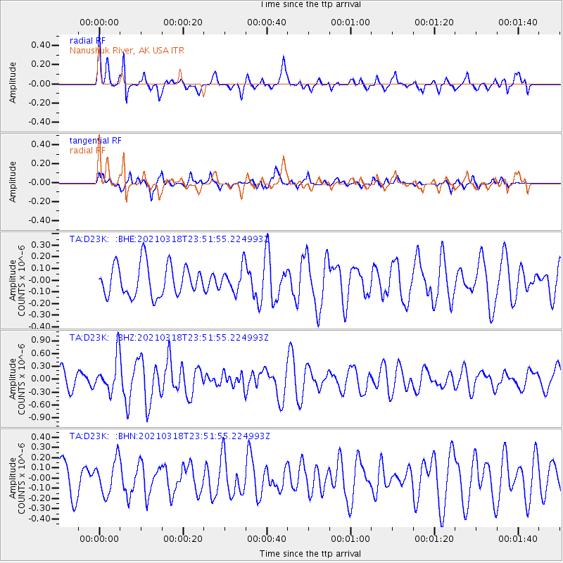
D23K Nanushuk River, AK USA - Earthquake Result Viewer
*The percent match for this event was below the threshold and hence no stack was calculated.
| Earthquake location: |
D'Entrecasteaux Islands Region |
| Earthquake latitude/longitude: |
-9.6/155.6 |
| Earthquake time(UTC): |
2021/03/18 (077) 23:39:41 GMT |
| Earthquake Depth: |
5.0 km |
| Earthquake Magnitude: |
5.5 Mww |
| Earthquake Catalog/Contributor: |
NEIC PDE/us |
|
| Network: |
TA USArray Transportable Network (new EarthScope stations) |
| Station: |
D23K Nanushuk River, AK USA |
| Lat/Lon: |
68.97 N/150.68 W |
| Elevation: |
406 m |
|
| Distance: |
86.7 deg |
| Az: |
16.953 deg |
| Baz: |
232.807 deg |
| Ray Param: |
$rayparam |
*The percent match for this event was below the threshold and hence was not used in the summary stack. |
|
| Radial Match: |
73.26444 % |
| Radial Bump: |
400 |
| Transverse Match: |
67.12805 % |
| Transverse Bump: |
400 |
| SOD ConfigId: |
24334971 |
| Insert Time: |
2021-04-01 23:50:21.569 +0000 |
| GWidth: |
2.5 |
| Max Bumps: |
400 |
| Tol: |
0.001 |
|
Signal To Noise
| Channel | StoN | STA | LTA |
| TA:D23K: :BHZ:20210318T23:51:55.224993Z | 1.7874789 | 4.2369996E-7 | 2.3703774E-7 |
| TA:D23K: :BHN:20210318T23:51:55.224993Z | 1.3403906 | 1.7437672E-7 | 1.3009397E-7 |
| TA:D23K: :BHE:20210318T23:51:55.224993Z | 0.805145 | 1.07939464E-7 | 1.3406213E-7 |
| Arrivals |
| Ps | |
| PpPs | |
| PsPs/PpSs | |


