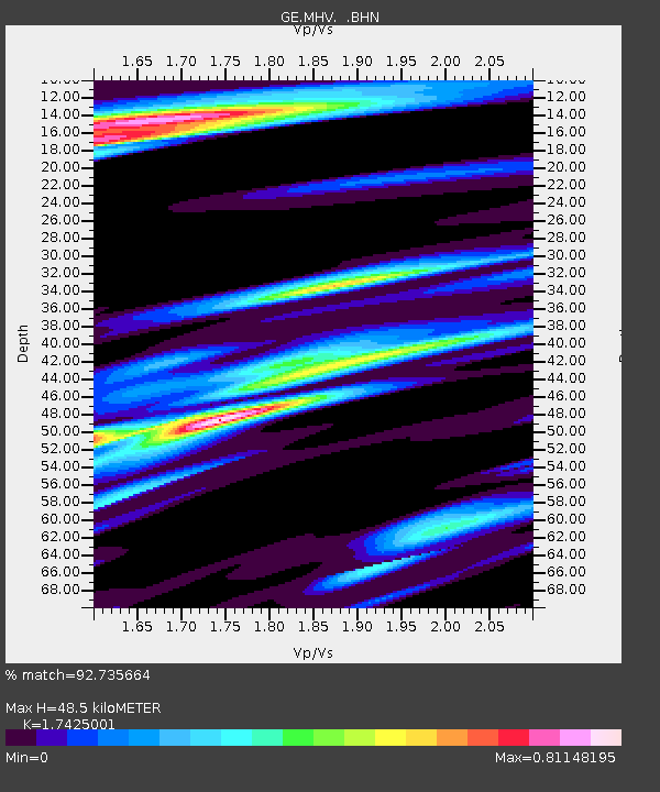
MHV GEOFON Station Michnevo, Russia - Earthquake Result Viewer

Earthquake location: Rat Islands, Aleutian Islands
Earthquake latitude/longitude: 51.3/178.0
Earthquake time(UTC): 2003/03/17 (076) 16:36:17 GMT
Earthquake Depth: 33 km
Earthquake Magnitude: 5.9 MB, 6.7 MS, 7.0 MW, 7.0 MW
Earthquake Catalog/Contributor: WHDF/NEIC
Network: GE GEOFON
Station: MHV GEOFON Station Michnevo, Russia
Lat/Lon: 54.96 N/37.77 E
Elevation: 150 m
Distance: 69.1 deg
Az: 336.724 deg
Baz: 25.493 deg
Ray Param: 0.05584022
Estimated Moho Depth: 48.5 km
Estimated Crust Vp/Vs: 1.74
Assumed Crust Vp: 6.516 km/s
Estimated Crust Vs: 3.74 km/s
Estimated Crust Poisson's Ratio: 0.25
Radial Match: 92.735664 %
Radial Bump: 392
Transverse Match: 75.10889 %
Transverse Bump: 400
SOD ConfigId: 4714
Insert Time: 2010-03-09 06:35:03.384 +0000
GWidth: 2.5
Max Bumps: 400
Tol: 0.001

Signal To Noise

ChannelStoNSTALTA
GE:MHV: :BHN:20030317T16:46:48.999026Z5.9744452.1304252E-63.5658965E-7
GE:MHV: :BHE:20030317T16:46:48.999026Z2.38708281.2163703E-65.095635E-7
GE:MHV: :BHZ:20030317T16:46:48.999026Z16.0146225.08022E-63.1722385E-7
Arrivals
Ps5.8 SECOND
PpPs20 SECOND
PsPs/PpSs25 SECOND