You are here: Home > Network List > GE - GEOFON Stations List
> Station MHV GEOFON Station Michnevo, Russia > Earthquake Result Viewer
MHV GEOFON Station Michnevo, Russia - Earthquake Result Viewer
| Earthquake location: |
Southern Xinjiang, China |
| Earthquake latitude/longitude: |
39.6/77.2 |
| Earthquake time(UTC): |
2003/02/24 (055) 02:03:41 GMT |
| Earthquake Depth: |
11 km |
| Earthquake Magnitude: |
5.8 MB, 6.3 MS, 6.4 MW, 6.3 MW |
| Earthquake Catalog/Contributor: |
WHDF/NEIC |
|
| Network: |
GE GEOFON |
| Station: |
MHV GEOFON Station Michnevo, Russia |
| Lat/Lon: |
54.96 N/37.77 E |
| Elevation: |
150 m |
|
| Distance: |
30.4 deg |
| Az: |
313.538 deg |
| Baz: |
103.841 deg |
| Ray Param: |
0.0793471 |
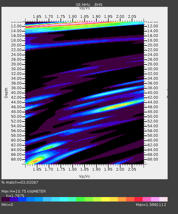
| Estimated Moho Depth: |
10.75 km |
| Estimated Crust Vp/Vs: |
1.79 |
| Assumed Crust Vp: |
6.516 km/s |
| Estimated Crust Vs: |
3.645 km/s |
| Estimated Crust Poisson's Ratio: |
0.27 |
|
| Radial Match: |
83.82067 % |
| Radial Bump: |
400 |
| Transverse Match: |
62.80264 % |
| Transverse Bump: |
400 |
| SOD ConfigId: |
4714 |
| Insert Time: |
2010-03-09 06:35:05.861 +0000 |
| GWidth: |
2.5 |
| Max Bumps: |
400 |
| Tol: |
0.001 |
|

Signal To Noise
| Channel | StoN | STA | LTA |
| GE:MHV: :BHN:20030224T02:09:22.697986Z | 1.2305956 | 2.6895233E-7 | 2.185546E-7 |
| GE:MHV: :BHE:20030224T02:09:22.697986Z | 0.9181026 | 3.033446E-7 | 3.304038E-7 |
| GE:MHV: :BHZ:20030224T02:09:22.697986Z | 2.1228125 | 6.890617E-7 | 3.245985E-7 |
| Arrivals |
| Ps | 1.4 SECOND |
| PpPs | 4.2 SECOND |
| PsPs/PpSs | 5.6 SECOND |


