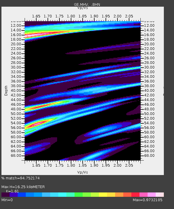
MHV GEOFON Station Michnevo, Russia - Earthquake Result Viewer

Earthquake location: Off East Coast Of Honshu, Japan
Earthquake latitude/longitude: 40.3/143.3
Earthquake time(UTC): 1998/05/14 (134) 18:56:23 GMT
Earthquake Depth: 33 km
Earthquake Magnitude: 5.8 MB, 5.7 MS, 5.9 UNKNOWN
Earthquake Catalog/Contributor: WHDF/NEIC
Network: GE GEOFON
Station: MHV GEOFON Station Michnevo, Russia
Lat/Lon: 54.96 N/37.77 E
Elevation: 150 m
Distance: 65.9 deg
Az: 322.5 deg
Baz: 53.883 deg
Ray Param: 0.057900507
Estimated Moho Depth: 16.25 km
Estimated Crust Vp/Vs: 1.61
Assumed Crust Vp: 6.516 km/s
Estimated Crust Vs: 4.047 km/s
Estimated Crust Poisson's Ratio: 0.19
Radial Match: 94.752174 %
Radial Bump: 389
Transverse Match: 87.31606 %
Transverse Bump: 400
SOD ConfigId: 4480
Insert Time: 2010-03-09 06:35:13.532 +0000
GWidth: 2.5
Max Bumps: 400
Tol: 0.001

Signal To Noise

ChannelStoNSTALTA
GE:MHV: :BHN:19980514T19:06:35.264014Z32.1658631.918935E-65.96575E-8
GE:MHV: :BHE:19980514T19:06:35.264014Z7.73552375.007012E-76.4727516E-8
GE:MHV: :BHZ:19980514T19:06:35.264014Z7.0321565.9409E-78.448191E-8
Arrivals
Ps1.6 SECOND
PpPs6.2 SECOND
PsPs/PpSs7.8 SECOND