You are here: Home > Network List > AZ - ANZA Regional Network Stations List
> Station SMER AZ.SMER > Earthquake Result Viewer
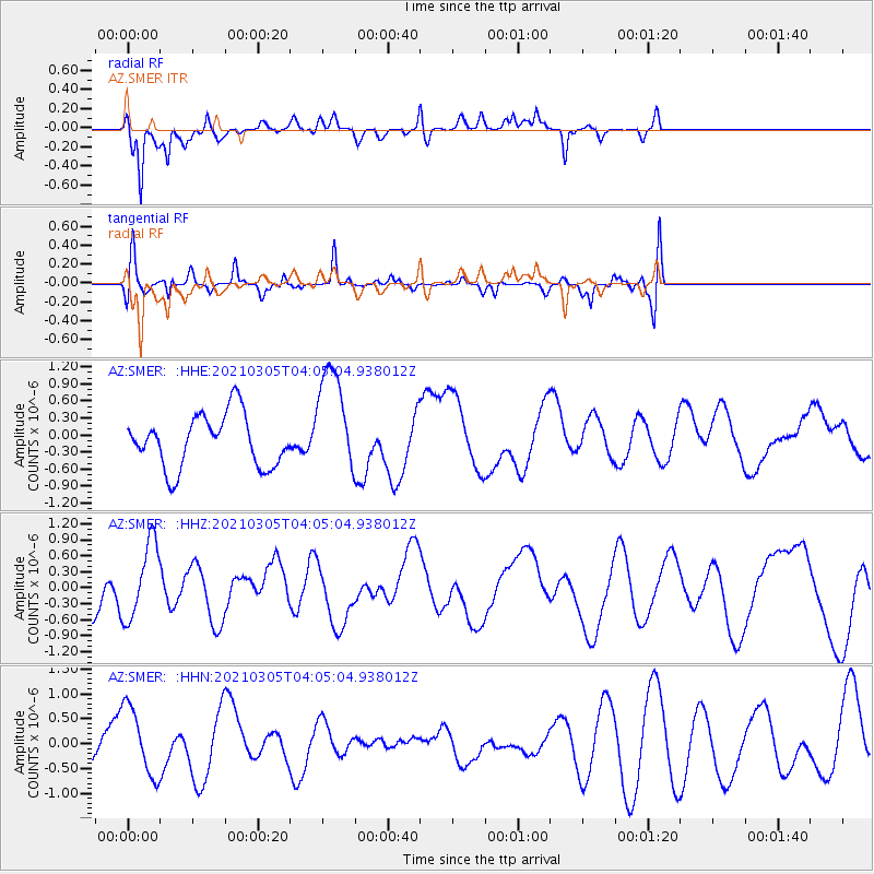
SMER AZ.SMER - Earthquake Result Viewer
*The percent match for this event was below the threshold and hence no stack was calculated.
| Earthquake location: |
Kermadec Islands Region |
| Earthquake latitude/longitude: |
-29.6/-176.7 |
| Earthquake time(UTC): |
2021/03/05 (064) 03:53:04 GMT |
| Earthquake Depth: |
10 km |
| Earthquake Magnitude: |
5.6 mww |
| Earthquake Catalog/Contributor: |
NEIC PDE/us |
|
| Network: |
AZ ANZA Regional Network |
| Station: |
SMER AZ.SMER |
| Lat/Lon: |
33.46 N/117.17 W |
| Elevation: |
355 m |
|
| Distance: |
84.3 deg |
| Az: |
46.397 deg |
| Baz: |
228.967 deg |
| Ray Param: |
$rayparam |
*The percent match for this event was below the threshold and hence was not used in the summary stack. |
|
| Radial Match: |
67.78579 % |
| Radial Bump: |
400 |
| Transverse Match: |
53.995358 % |
| Transverse Bump: |
400 |
| SOD ConfigId: |
24334971 |
| Insert Time: |
2021-04-02 05:18:16.975 +0000 |
| GWidth: |
2.5 |
| Max Bumps: |
400 |
| Tol: |
0.001 |
|
Signal To Noise
| Channel | StoN | STA | LTA |
| AZ:SMER: :HHZ:20210305T04:05:04.938012Z | 1.3574498 | 7.1552654E-7 | 5.271109E-7 |
| AZ:SMER: :HHN:20210305T04:05:04.938012Z | 1.685507 | 6.989085E-7 | 4.146577E-7 |
| AZ:SMER: :HHE:20210305T04:05:04.938012Z | 2.0524235 | 9.484267E-7 | 4.621009E-7 |
| Arrivals |
| Ps | |
| PpPs | |
| PsPs/PpSs | |


