You are here: Home > Network List > US - United States National Seismic Network Stations List
> Station AMTX Amarillo, Texas, USA > Earthquake Result Viewer
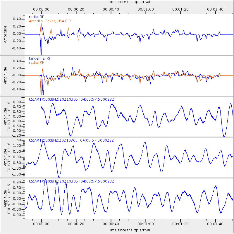
AMTX Amarillo, Texas, USA - Earthquake Result Viewer
*The percent match for this event was below the threshold and hence no stack was calculated.
| Earthquake location: |
Kermadec Islands Region |
| Earthquake latitude/longitude: |
-29.6/-176.7 |
| Earthquake time(UTC): |
2021/03/05 (064) 03:53:04 GMT |
| Earthquake Depth: |
10 km |
| Earthquake Magnitude: |
5.6 mww |
| Earthquake Catalog/Contributor: |
NEIC PDE/us |
|
| Network: |
US United States National Seismic Network |
| Station: |
AMTX Amarillo, Texas, USA |
| Lat/Lon: |
34.53 N/101.41 W |
| Elevation: |
1010 m |
|
| Distance: |
95.4 deg |
| Az: |
53.338 deg |
| Baz: |
237.794 deg |
| Ray Param: |
$rayparam |
*The percent match for this event was below the threshold and hence was not used in the summary stack. |
|
| Radial Match: |
63.176144 % |
| Radial Bump: |
400 |
| Transverse Match: |
63.37457 % |
| Transverse Bump: |
400 |
| SOD ConfigId: |
24334971 |
| Insert Time: |
2021-04-02 05:27:34.080 +0000 |
| GWidth: |
2.5 |
| Max Bumps: |
400 |
| Tol: |
0.001 |
|
Signal To Noise
| Channel | StoN | STA | LTA |
| US:AMTX:00:BHZ:20210305T04:05:57.500023Z | 1.9671158 | 9.568471E-7 | 4.8642136E-7 |
| US:AMTX:00:BH1:20210305T04:05:57.500023Z | 1.8874816 | 6.32993E-7 | 3.353638E-7 |
| US:AMTX:00:BH2:20210305T04:05:57.500023Z | 1.0520548 | 5.331055E-7 | 5.0672793E-7 |
| Arrivals |
| Ps | |
| PpPs | |
| PsPs/PpSs | |


