You are here: Home > Network List > CM - Red Sismologica Nacional de Columbia Stations List
> Station PRV Islas San Andres y Providencia, Colombia > Earthquake Result Viewer
PRV Islas San Andres y Providencia, Colombia - Earthquake Result Viewer
| Earthquake location: |
Tonga Islands |
| Earthquake latitude/longitude: |
-15.4/-173.2 |
| Earthquake time(UTC): |
2017/11/04 (308) 09:00:19 GMT |
| Earthquake Depth: |
10 km |
| Earthquake Magnitude: |
6.8 Mww |
| Earthquake Catalog/Contributor: |
NEIC PDE/us |
|
| Network: |
CM Red Sismologica Nacional de Columbia |
| Station: |
PRV Islas San Andres y Providencia, Colombia |
| Lat/Lon: |
13.38 N/81.36 W |
| Elevation: |
205 m |
|
| Distance: |
95.2 deg |
| Az: |
77.622 deg |
| Baz: |
255.523 deg |
| Ray Param: |
0.04084138 |
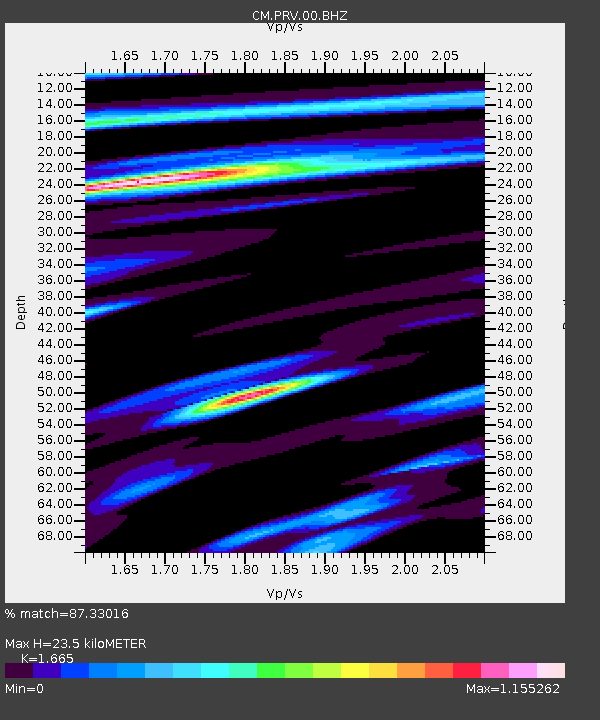
| Estimated Moho Depth: |
23.5 km |
| Estimated Crust Vp/Vs: |
1.66 |
| Assumed Crust Vp: |
6.048 km/s |
| Estimated Crust Vs: |
3.632 km/s |
| Estimated Crust Poisson's Ratio: |
0.22 |
|
| Radial Match: |
87.33016 % |
| Radial Bump: |
400 |
| Transverse Match: |
87.20519 % |
| Transverse Bump: |
400 |
| SOD ConfigId: |
2429771 |
| Insert Time: |
2017-11-18 09:01:38.487 +0000 |
| GWidth: |
2.5 |
| Max Bumps: |
400 |
| Tol: |
0.001 |
|

Signal To Noise
| Channel | StoN | STA | LTA |
| CM:PRV:00:BHZ:20171104T09:13:11.969014Z | 3.0392287 | 1.6033384E-7 | 5.275478E-8 |
| CM:PRV:00:BHN:20171104T09:13:11.969014Z | 1.145459 | 7.466966E-8 | 6.518754E-8 |
| CM:PRV:00:BHE:20171104T09:13:11.969014Z | 0.8114644 | 4.2030877E-8 | 5.1796324E-8 |
| Arrivals |
| Ps | 2.6 SECOND |
| PpPs | 10 SECOND |
| PsPs/PpSs | 13 SECOND |


