You are here: Home > Network List > GS - US Geological Survey Networks Stations List
> Station ASL8 Albuquerque, New Mexico, USA > Earthquake Result Viewer
ASL8 Albuquerque, New Mexico, USA - Earthquake Result Viewer
| Earthquake location: |
Tonga Islands |
| Earthquake latitude/longitude: |
-15.4/-173.2 |
| Earthquake time(UTC): |
2017/11/04 (308) 09:00:19 GMT |
| Earthquake Depth: |
10 km |
| Earthquake Magnitude: |
6.8 Mww |
| Earthquake Catalog/Contributor: |
NEIC PDE/us |
|
| Network: |
GS US Geological Survey Networks |
| Station: |
ASL8 Albuquerque, New Mexico, USA |
| Lat/Lon: |
34.95 N/106.46 W |
| Elevation: |
1820 m |
|
| Distance: |
80.6 deg |
| Az: |
49.91 deg |
| Baz: |
243.954 deg |
| Ray Param: |
0.04813852 |
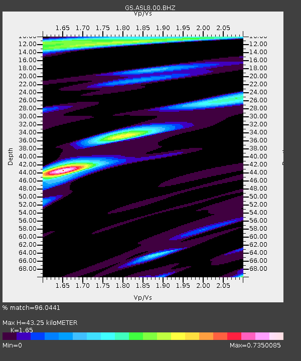
| Estimated Moho Depth: |
43.25 km |
| Estimated Crust Vp/Vs: |
1.65 |
| Assumed Crust Vp: |
6.502 km/s |
| Estimated Crust Vs: |
3.94 km/s |
| Estimated Crust Poisson's Ratio: |
0.21 |
|
| Radial Match: |
96.0441 % |
| Radial Bump: |
398 |
| Transverse Match: |
94.21661 % |
| Transverse Bump: |
356 |
| SOD ConfigId: |
2429771 |
| Insert Time: |
2017-11-18 09:02:26.265 +0000 |
| GWidth: |
2.5 |
| Max Bumps: |
400 |
| Tol: |
0.001 |
|

Signal To Noise
| Channel | StoN | STA | LTA |
| GS:ASL8:00:BHZ:20171104T09:12:01.443989Z | 40.404243 | 2.8115583E-6 | 6.958572E-8 |
| GS:ASL8:00:BH1:20171104T09:12:01.443989Z | 8.081861 | 4.94327E-7 | 6.1165004E-8 |
| GS:ASL8:00:BH2:20171104T09:12:01.443989Z | 12.502223 | 7.075995E-7 | 5.6597898E-8 |
| Arrivals |
| Ps | 4.5 SECOND |
| PpPs | 17 SECOND |
| PsPs/PpSs | 22 SECOND |


