You are here: Home > Network List > TA - USArray Transportable Network (new EarthScope stations) Stations List
> Station F14K Arctic Creek, AK, USA > Earthquake Result Viewer
F14K Arctic Creek, AK, USA - Earthquake Result Viewer
| Earthquake location: |
Xizang |
| Earthquake latitude/longitude: |
31.9/92.9 |
| Earthquake time(UTC): |
2021/03/19 (078) 06:11:27 GMT |
| Earthquake Depth: |
10 km |
| Earthquake Magnitude: |
5.7 Mww |
| Earthquake Catalog/Contributor: |
NEIC PDE/us |
|
| Network: |
TA USArray Transportable Network (new EarthScope stations) |
| Station: |
F14K Arctic Creek, AK, USA |
| Lat/Lon: |
65.47 N/166.33 W |
| Elevation: |
266 m |
|
| Distance: |
65.7 deg |
| Az: |
26.74 deg |
| Baz: |
293.541 deg |
| Ray Param: |
0.058096062 |
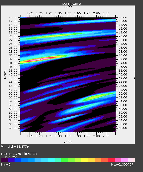
| Estimated Moho Depth: |
31.75 km |
| Estimated Crust Vp/Vs: |
1.71 |
| Assumed Crust Vp: |
6.307 km/s |
| Estimated Crust Vs: |
3.699 km/s |
| Estimated Crust Poisson's Ratio: |
0.24 |
|
| Radial Match: |
88.4776 % |
| Radial Bump: |
395 |
| Transverse Match: |
73.188255 % |
| Transverse Bump: |
400 |
| SOD ConfigId: |
24334971 |
| Insert Time: |
2021-04-02 06:26:41.895 +0000 |
| GWidth: |
2.5 |
| Max Bumps: |
400 |
| Tol: |
0.001 |
|

Signal To Noise
| Channel | StoN | STA | LTA |
| TA:F14K: :BHZ:20210319T06:21:40.775029Z | 5.985956 | 7.444761E-7 | 1.2437046E-7 |
| TA:F14K: :BHN:20210319T06:21:40.775029Z | 2.2557335 | 1.5985947E-7 | 7.086807E-8 |
| TA:F14K: :BHE:20210319T06:21:40.775029Z | 4.5696855 | 3.575039E-7 | 7.823381E-8 |
| Arrivals |
| Ps | 3.7 SECOND |
| PpPs | 13 SECOND |
| PsPs/PpSs | 17 SECOND |


