You are here: Home > Network List > TA - USArray Transportable Network (new EarthScope stations) Stations List
> Station G16K Koyuk River, AK, USA > Earthquake Result Viewer
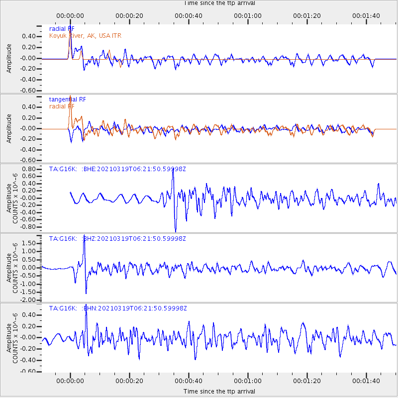
G16K Koyuk River, AK, USA - Earthquake Result Viewer
*The percent match for this event was below the threshold and hence no stack was calculated.
| Earthquake location: |
Xizang |
| Earthquake latitude/longitude: |
31.9/92.9 |
| Earthquake time(UTC): |
2021/03/19 (078) 06:11:27 GMT |
| Earthquake Depth: |
10 km |
| Earthquake Magnitude: |
5.7 Mww |
| Earthquake Catalog/Contributor: |
NEIC PDE/us |
|
| Network: |
TA USArray Transportable Network (new EarthScope stations) |
| Station: |
G16K Koyuk River, AK, USA |
| Lat/Lon: |
65.39 N/162.35 W |
| Elevation: |
169 m |
|
| Distance: |
67.2 deg |
| Az: |
26.048 deg |
| Baz: |
296.875 deg |
| Ray Param: |
$rayparam |
*The percent match for this event was below the threshold and hence was not used in the summary stack. |
|
| Radial Match: |
70.9499 % |
| Radial Bump: |
400 |
| Transverse Match: |
62.139374 % |
| Transverse Bump: |
400 |
| SOD ConfigId: |
24334971 |
| Insert Time: |
2021-04-02 06:26:58.760 +0000 |
| GWidth: |
2.5 |
| Max Bumps: |
400 |
| Tol: |
0.001 |
|
Signal To Noise
| Channel | StoN | STA | LTA |
| TA:G16K: :BHZ:20210319T06:21:50.59998Z | 4.9711947 | 6.2569984E-7 | 1.2586509E-7 |
| TA:G16K: :BHN:20210319T06:21:50.59998Z | 0.7416826 | 8.3823274E-8 | 1.1301771E-7 |
| TA:G16K: :BHE:20210319T06:21:50.59998Z | 2.9566 | 2.4618296E-7 | 8.326556E-8 |
| Arrivals |
| Ps | |
| PpPs | |
| PsPs/PpSs | |


