You are here: Home > Network List > TA - USArray Transportable Network (new EarthScope stations) Stations List
> Station L15K Ungalak Mountain, AK, USA > Earthquake Result Viewer
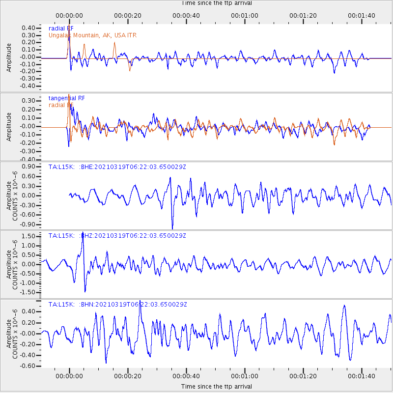
L15K Ungalak Mountain, AK, USA - Earthquake Result Viewer
*The percent match for this event was below the threshold and hence no stack was calculated.
| Earthquake location: |
Xizang |
| Earthquake latitude/longitude: |
31.9/92.9 |
| Earthquake time(UTC): |
2021/03/19 (078) 06:11:27 GMT |
| Earthquake Depth: |
10 km |
| Earthquake Magnitude: |
5.7 Mww |
| Earthquake Catalog/Contributor: |
NEIC PDE/us |
|
| Network: |
TA USArray Transportable Network (new EarthScope stations) |
| Station: |
L15K Ungalak Mountain, AK, USA |
| Lat/Lon: |
61.68 N/161.49 W |
| Elevation: |
219 m |
|
| Distance: |
69.3 deg |
| Az: |
29.402 deg |
| Baz: |
298.893 deg |
| Ray Param: |
$rayparam |
*The percent match for this event was below the threshold and hence was not used in the summary stack. |
|
| Radial Match: |
56.807842 % |
| Radial Bump: |
400 |
| Transverse Match: |
61.820683 % |
| Transverse Bump: |
400 |
| SOD ConfigId: |
24334971 |
| Insert Time: |
2021-04-02 06:27:31.930 +0000 |
| GWidth: |
2.5 |
| Max Bumps: |
400 |
| Tol: |
0.001 |
|
Signal To Noise
| Channel | StoN | STA | LTA |
| TA:L15K: :BHZ:20210319T06:22:03.650029Z | 3.7013896 | 6.723459E-7 | 1.816469E-7 |
| TA:L15K: :BHN:20210319T06:22:03.650029Z | 1.090292 | 1.1019302E-7 | 1.0106745E-7 |
| TA:L15K: :BHE:20210319T06:22:03.650029Z | 1.7019916 | 2.573183E-7 | 1.5118658E-7 |
| Arrivals |
| Ps | |
| PpPs | |
| PsPs/PpSs | |


