You are here: Home > Network List > TA - USArray Transportable Network (new EarthScope stations) Stations List
> Station M31M Drury Creek, Yukon, CA > Earthquake Result Viewer
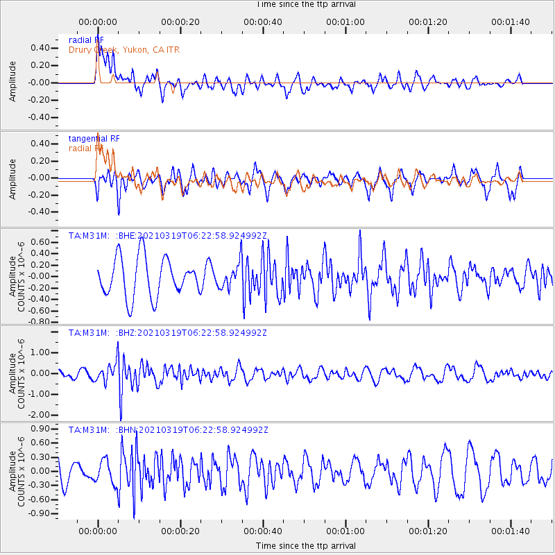
M31M Drury Creek, Yukon, CA - Earthquake Result Viewer
*The percent match for this event was below the threshold and hence no stack was calculated.
| Earthquake location: |
Xizang |
| Earthquake latitude/longitude: |
31.9/92.9 |
| Earthquake time(UTC): |
2021/03/19 (078) 06:11:27 GMT |
| Earthquake Depth: |
10 km |
| Earthquake Magnitude: |
5.7 Mww |
| Earthquake Catalog/Contributor: |
NEIC PDE/us |
|
| Network: |
TA USArray Transportable Network (new EarthScope stations) |
| Station: |
M31M Drury Creek, Yukon, CA |
| Lat/Lon: |
62.20 N/134.39 W |
| Elevation: |
639 m |
|
| Distance: |
78.8 deg |
| Az: |
20.558 deg |
| Baz: |
320.427 deg |
| Ray Param: |
$rayparam |
*The percent match for this event was below the threshold and hence was not used in the summary stack. |
|
| Radial Match: |
56.234047 % |
| Radial Bump: |
400 |
| Transverse Match: |
63.853767 % |
| Transverse Bump: |
400 |
| SOD ConfigId: |
24334971 |
| Insert Time: |
2021-04-02 06:27:41.010 +0000 |
| GWidth: |
2.5 |
| Max Bumps: |
400 |
| Tol: |
0.001 |
|
Signal To Noise
| Channel | StoN | STA | LTA |
| TA:M31M: :BHZ:20210319T06:22:58.924992Z | 2.5822206 | 4.926578E-7 | 1.9078844E-7 |
| TA:M31M: :BHN:20210319T06:22:58.924992Z | 1.1609923 | 2.621974E-7 | 2.2583905E-7 |
| TA:M31M: :BHE:20210319T06:22:58.924992Z | 0.6681426 | 2.2887932E-7 | 3.4256055E-7 |
| Arrivals |
| Ps | |
| PpPs | |
| PsPs/PpSs | |


