You are here: Home > Network List > GS - US Geological Survey Networks Stations List
> Station KAN14 Manchester OK Station > Earthquake Result Viewer
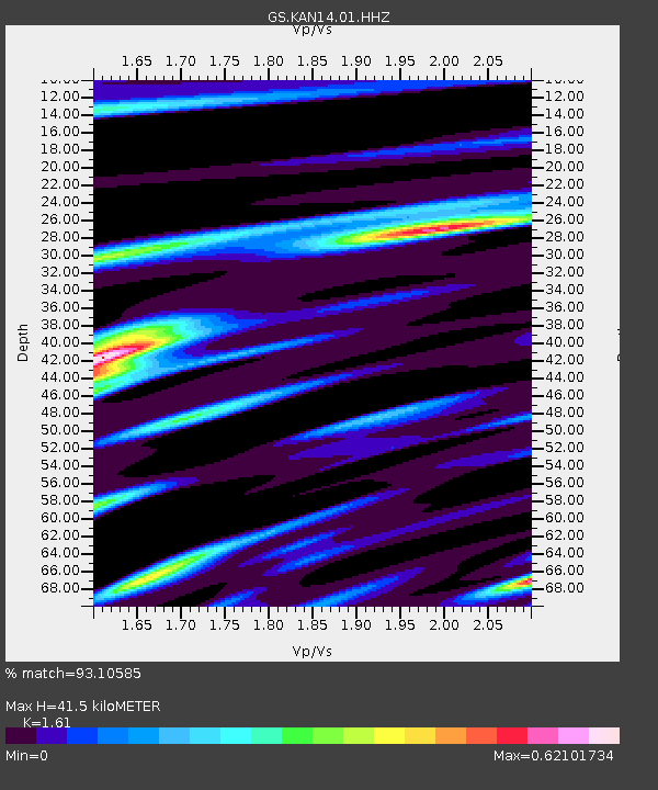
KAN14 Manchester OK Station - Earthquake Result Viewer
| Earthquake location: |
Tonga Islands |
| Earthquake latitude/longitude: |
-15.4/-173.2 |
| Earthquake time(UTC): |
2017/11/04 (308) 09:00:19 GMT |
| Earthquake Depth: |
10 km |
| Earthquake Magnitude: |
6.8 Mww |
| Earthquake Catalog/Contributor: |
NEIC PDE/us |
|
| Network: |
GS US Geological Survey Networks |
| Station: |
KAN14 Manchester OK Station |
| Lat/Lon: |
36.96 N/97.96 W |
| Elevation: |
363 m |
|
| Distance: |
87.8 deg |
| Az: |
50.827 deg |
| Baz: |
249.018 deg |
| Ray Param: |
0.04309213 |
| Estimated Moho Depth: |
41.5 km |
| Estimated Crust Vp/Vs: |
1.61 |
| Assumed Crust Vp: |
6.483 km/s |
| Estimated Crust Vs: |
4.026 km/s |
| Estimated Crust Poisson's Ratio: |
0.19 |
|
| Radial Match: |
93.10585 % |
| Radial Bump: |
304 |
| Transverse Match: |
62.115746 % |
| Transverse Bump: |
400 |
| SOD ConfigId: |
2429771 |
| Insert Time: |
2017-11-18 09:03:08.301 +0000 |
| GWidth: |
2.5 |
| Max Bumps: |
400 |
| Tol: |
0.001 |
|

Signal To Noise
| Channel | StoN | STA | LTA |
| GS:KAN14:01:HHZ:20171104T09:12:37.45998Z | 11.665498 | 1.6680004E-6 | 1.429858E-7 |
| GS:KAN14:01:HHN:20171104T09:12:37.45998Z | 1.0118825 | 4.7853075E-7 | 4.7291138E-7 |
| GS:KAN14:01:HHE:20171104T09:12:37.45998Z | 1.1959633 | 4.0983676E-7 | 3.426834E-7 |
| Arrivals |
| Ps | 4.0 SECOND |
| PpPs | 16 SECOND |
| PsPs/PpSs | 20 SECOND |


