You are here: Home > Network List > UW - Pacific Northwest Regional Seismic Network Stations List
> Station HOOD Mt Hood Meadows, OR CREST BB SMO > Earthquake Result Viewer
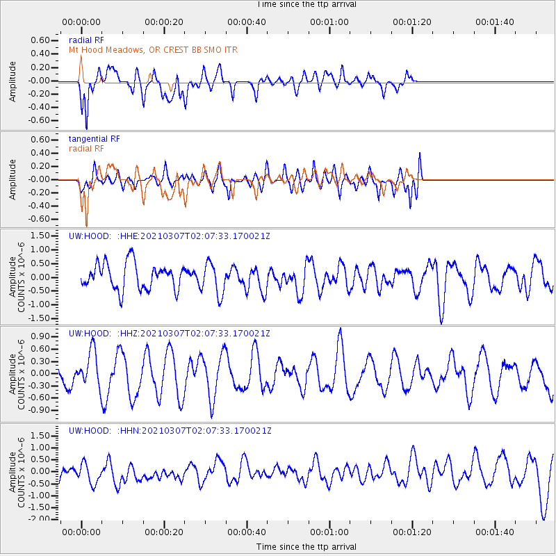
HOOD Mt Hood Meadows, OR CREST BB SMO - Earthquake Result Viewer
*The percent match for this event was below the threshold and hence no stack was calculated.
| Earthquake location: |
Kermadec Islands Region |
| Earthquake latitude/longitude: |
-28.5/-176.6 |
| Earthquake time(UTC): |
2021/03/07 (066) 01:55:10 GMT |
| Earthquake Depth: |
8.0 km |
| Earthquake Magnitude: |
5.5 Mww |
| Earthquake Catalog/Contributor: |
NEIC PDE/us |
|
| Network: |
UW Pacific Northwest Regional Seismic Network |
| Station: |
HOOD Mt Hood Meadows, OR CREST BB SMO |
| Lat/Lon: |
45.32 N/121.65 W |
| Elevation: |
1520 m |
|
| Distance: |
88.8 deg |
| Az: |
35.284 deg |
| Baz: |
226.127 deg |
| Ray Param: |
$rayparam |
*The percent match for this event was below the threshold and hence was not used in the summary stack. |
|
| Radial Match: |
56.211185 % |
| Radial Bump: |
400 |
| Transverse Match: |
62.643867 % |
| Transverse Bump: |
400 |
| SOD ConfigId: |
24334971 |
| Insert Time: |
2021-04-02 22:43:36.005 +0000 |
| GWidth: |
2.5 |
| Max Bumps: |
400 |
| Tol: |
0.001 |
|
Signal To Noise
| Channel | StoN | STA | LTA |
| UW:HOOD: :HHZ:20210307T02:07:33.170021Z | 1.3709147 | 4.4445963E-7 | 3.2420664E-7 |
| UW:HOOD: :HHN:20210307T02:07:33.170021Z | 1.1058425 | 4.5993232E-7 | 4.1591124E-7 |
| UW:HOOD: :HHE:20210307T02:07:33.170021Z | 1.2691455 | 6.0133533E-7 | 4.7381118E-7 |
| Arrivals |
| Ps | |
| PpPs | |
| PsPs/PpSs | |


