You are here: Home > Network List > IU - Global Seismograph Network (GSN - IRIS/USGS) Stations List
> Station CTAO Charters Towers, Australia > Earthquake Result Viewer
CTAO Charters Towers, Australia - Earthquake Result Viewer

| Earthquake location: |
Tonga Islands |
| Earthquake latitude/longitude: |
-15.4/-173.2 |
| Earthquake time(UTC): |
2017/11/04 (308) 09:00:19 GMT |
| Earthquake Depth: |
10 km |
| Earthquake Magnitude: |
6.8 Mww |
| Earthquake Catalog/Contributor: |
NEIC PDE/us |
|
| Network: |
IU Global Seismograph Network (GSN - IRIS/USGS) |
| Station: |
CTAO Charters Towers, Australia |
| Lat/Lon: |
20.09 S/146.25 E |
| Elevation: |
357 m |
|
| Distance: |
38.8 deg |
| Az: |
256.967 deg |
| Baz: |
89.725 deg |
| Ray Param: |
0.07534039 |
| Estimated Moho Depth: |
31.75 km |
| Estimated Crust Vp/Vs: |
1.83 |
| Assumed Crust Vp: |
6.522 km/s |
| Estimated Crust Vs: |
3.559 km/s |
| Estimated Crust Poisson's Ratio: |
0.29 |
|
| Radial Match: |
96.62995 % |
| Radial Bump: |
107 |
| Transverse Match: |
89.09121 % |
| Transverse Bump: |
358 |
| SOD ConfigId: |
2429771 |
| Insert Time: |
2017-11-18 09:04:09.755 +0000 |
| GWidth: |
2.5 |
| Max Bumps: |
400 |
| Tol: |
0.001 |
|
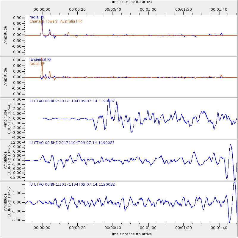
Signal To Noise
| Channel | StoN | STA | LTA |
| IU:CTAO:00:BHZ:20171104T09:07:14.119008Z | 17.899275 | 1.6851843E-6 | 9.414819E-8 |
| IU:CTAO:00:BH1:20171104T09:07:14.119008Z | 0.5661213 | 7.6176825E-8 | 1.3455919E-7 |
| IU:CTAO:00:BH2:20171104T09:07:14.119008Z | 12.718603 | 1.018361E-6 | 8.006862E-8 |
| Arrivals |
| Ps | 4.4 SECOND |
| PpPs | 13 SECOND |
| PsPs/PpSs | 17 SECOND |


