You are here: Home > Network List > IU - Global Seismograph Network (GSN - IRIS/USGS) Stations List
> Station POHA Pohakuloa, Hawaii, USA > Earthquake Result Viewer
POHA Pohakuloa, Hawaii, USA - Earthquake Result Viewer

| Earthquake location: |
Tonga Islands |
| Earthquake latitude/longitude: |
-15.4/-173.2 |
| Earthquake time(UTC): |
2017/11/04 (308) 09:00:19 GMT |
| Earthquake Depth: |
10 km |
| Earthquake Magnitude: |
6.8 Mww |
| Earthquake Catalog/Contributor: |
NEIC PDE/us |
|
| Network: |
IU Global Seismograph Network (GSN - IRIS/USGS) |
| Station: |
POHA Pohakuloa, Hawaii, USA |
| Lat/Lon: |
19.76 N/155.53 W |
| Elevation: |
1990 m |
|
| Distance: |
39.0 deg |
| Az: |
27.052 deg |
| Baz: |
207.765 deg |
| Ray Param: |
0.0752433 |
| Estimated Moho Depth: |
45.0 km |
| Estimated Crust Vp/Vs: |
1.66 |
| Assumed Crust Vp: |
5.195 km/s |
| Estimated Crust Vs: |
3.13 km/s |
| Estimated Crust Poisson's Ratio: |
0.22 |
|
| Radial Match: |
81.494 % |
| Radial Bump: |
400 |
| Transverse Match: |
77.39459 % |
| Transverse Bump: |
400 |
| SOD ConfigId: |
2429771 |
| Insert Time: |
2017-11-18 09:04:34.350 +0000 |
| GWidth: |
2.5 |
| Max Bumps: |
400 |
| Tol: |
0.001 |
|
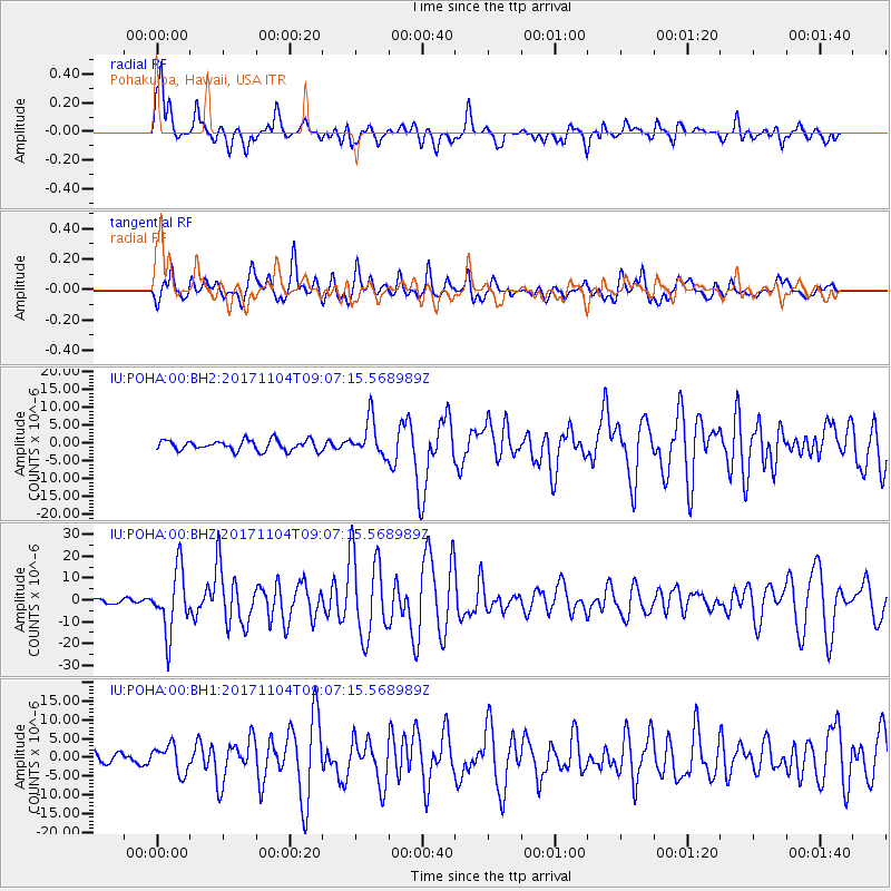
Signal To Noise
| Channel | StoN | STA | LTA |
| IU:POHA:00:BHZ:20171104T09:07:15.568989Z | 9.929928 | 1.4057801E-5 | 1.4157002E-6 |
| IU:POHA:00:BH1:20171104T09:07:15.568989Z | 1.860438 | 3.6763408E-6 | 1.976062E-6 |
| IU:POHA:00:BH2:20171104T09:07:15.568989Z | 3.4726057 | 5.059354E-6 | 1.456933E-6 |
| Arrivals |
| Ps | 6.0 SECOND |
| PpPs | 22 SECOND |
| PsPs/PpSs | 28 SECOND |


