You are here: Home > Network List > GE - GEOFON Stations List
> Station IBBN RUB/GEOFON Station Ibbenbueren, Germany > Earthquake Result Viewer
IBBN RUB/GEOFON Station Ibbenbueren, Germany - Earthquake Result Viewer
| Earthquake location: |
Near Coast Of Peru |
| Earthquake latitude/longitude: |
-17.7/-71.6 |
| Earthquake time(UTC): |
2001/06/26 (177) 04:18:31 GMT |
| Earthquake Depth: |
24 km |
| Earthquake Magnitude: |
6.2 MB, 6.7 MS, 6.8 MW, 6.7 ME |
| Earthquake Catalog/Contributor: |
WHDF/NEIC |
|
| Network: |
GE GEOFON |
| Station: |
IBBN RUB/GEOFON Station Ibbenbueren, Germany |
| Lat/Lon: |
52.31 N/7.76 E |
| Elevation: |
140 m |
|
| Distance: |
97.6 deg |
| Az: |
37.504 deg |
| Baz: |
250.905 deg |
| Ray Param: |
0.04016871 |
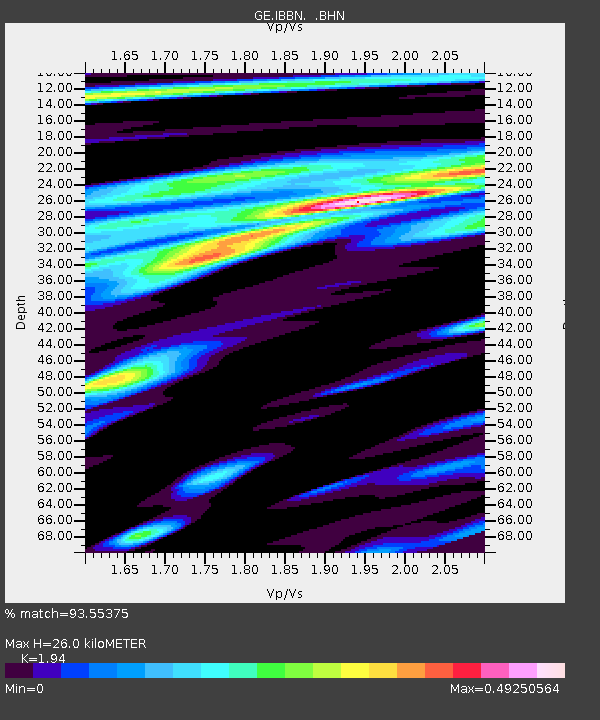
| Estimated Moho Depth: |
26.0 km |
| Estimated Crust Vp/Vs: |
1.94 |
| Assumed Crust Vp: |
6.1 km/s |
| Estimated Crust Vs: |
3.144 km/s |
| Estimated Crust Poisson's Ratio: |
0.32 |
|
| Radial Match: |
93.55375 % |
| Radial Bump: |
400 |
| Transverse Match: |
83.04465 % |
| Transverse Bump: |
400 |
| SOD ConfigId: |
4714 |
| Insert Time: |
2010-03-09 06:37:53.346 +0000 |
| GWidth: |
2.5 |
| Max Bumps: |
400 |
| Tol: |
0.001 |
|

Signal To Noise
| Channel | StoN | STA | LTA |
| GE:IBBN: :BHN:20010626T04:31:31.793025Z | 1.8312337 | 2.9230355E-7 | 1.5962111E-7 |
| GE:IBBN: :BHE:20010626T04:31:31.793025Z | 1.3474092 | 1.6042786E-7 | 1.1906394E-7 |
| GE:IBBN: :BHZ:20010626T04:31:31.793025Z | 5.1280446 | 6.181525E-7 | 1.205435E-7 |
| Arrivals |
| Ps | 4.1 SECOND |
| PpPs | 12 SECOND |
| PsPs/PpSs | 16 SECOND |


