You are here: Home > Network List > GE - GEOFON Stations List
> Station IBBN RUB/GEOFON Station Ibbenbueren, Germany > Earthquake Result Viewer
IBBN RUB/GEOFON Station Ibbenbueren, Germany - Earthquake Result Viewer
| Earthquake location: |
Western Iran |
| Earthquake latitude/longitude: |
35.6/49.0 |
| Earthquake time(UTC): |
2002/06/22 (173) 02:58:21 GMT |
| Earthquake Depth: |
10 km |
| Earthquake Magnitude: |
6.2 MB, 6.4 MS, 6.5 MW, 6.5 MW |
| Earthquake Catalog/Contributor: |
WHDF/NEIC |
|
| Network: |
GE GEOFON |
| Station: |
IBBN RUB/GEOFON Station Ibbenbueren, Germany |
| Lat/Lon: |
52.31 N/7.76 E |
| Elevation: |
140 m |
|
| Distance: |
33.5 deg |
| Az: |
312.824 deg |
| Baz: |
103.302 deg |
| Ray Param: |
0.07816404 |
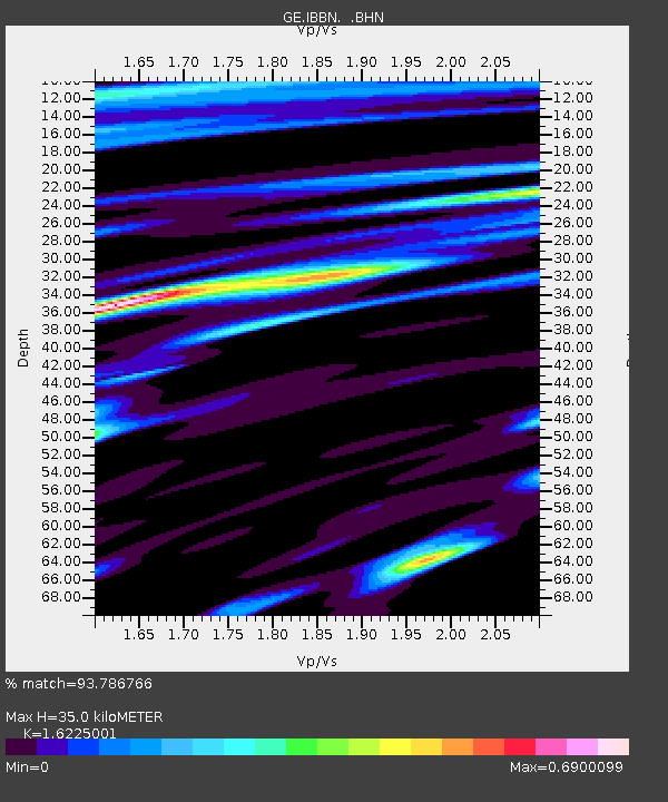
| Estimated Moho Depth: |
35.0 km |
| Estimated Crust Vp/Vs: |
1.62 |
| Assumed Crust Vp: |
6.1 km/s |
| Estimated Crust Vs: |
3.76 km/s |
| Estimated Crust Poisson's Ratio: |
0.19 |
|
| Radial Match: |
93.786766 % |
| Radial Bump: |
334 |
| Transverse Match: |
79.2494 % |
| Transverse Bump: |
400 |
| SOD ConfigId: |
20082 |
| Insert Time: |
2010-03-09 06:37:59.117 +0000 |
| GWidth: |
2.5 |
| Max Bumps: |
400 |
| Tol: |
0.001 |
|

Signal To Noise
| Channel | StoN | STA | LTA |
| GE:IBBN: :BHN:20020622T03:04:30.332013Z | 0.95274836 | 1.2336587E-7 | 1.294842E-7 |
| GE:IBBN: :BHE:20020622T03:04:30.332013Z | 9.562786 | 1.0249069E-6 | 1.0717659E-7 |
| GE:IBBN: :BHZ:20020622T03:04:30.332013Z | 17.774647 | 1.8661036E-6 | 1.0498681E-7 |
| Arrivals |
| Ps | 3.9 SECOND |
| PpPs | 14 SECOND |
| PsPs/PpSs | 18 SECOND |


