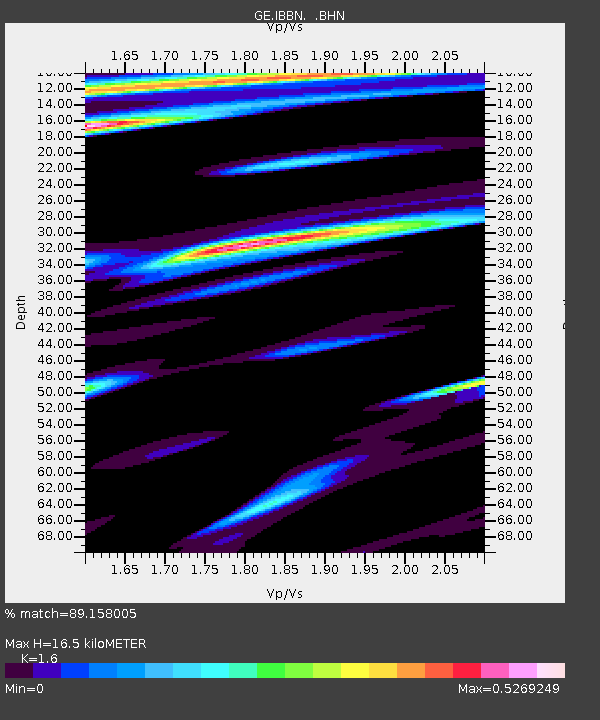
IBBN RUB/GEOFON Station Ibbenbueren, Germany - Earthquake Result Viewer

Earthquake location: Hindu Kush Region, Afghanistan
Earthquake latitude/longitude: 36.1/69.3
Earthquake time(UTC): 2002/03/25 (084) 14:56:33 GMT
Earthquake Depth: 8.0 km
Earthquake Magnitude: 5.9 MB, 6.2 MS, 6.1 MW, 6.0 MW
Earthquake Catalog/Contributor: WHDF/NEIC
Network: GE GEOFON
Station: IBBN RUB/GEOFON Station Ibbenbueren, Germany
Lat/Lon: 52.31 N/7.76 E
Elevation: 140 m
Distance: 45.6 deg
Az: 310.93 deg
Baz: 85.565 deg
Ray Param: 0.07116969
Estimated Moho Depth: 16.5 km
Estimated Crust Vp/Vs: 1.60
Assumed Crust Vp: 6.1 km/s
Estimated Crust Vs: 3.812 km/s
Estimated Crust Poisson's Ratio: 0.18
Radial Match: 89.158005 %
Radial Bump: 400
Transverse Match: 33.27843 %
Transverse Bump: 400
SOD ConfigId: 20082
Insert Time: 2010-03-09 06:38:05.824 +0000
GWidth: 2.5
Max Bumps: 400
Tol: 0.001

Signal To Noise

ChannelStoNSTALTA
GE:IBBN: :BHN:20020325T15:04:23.533013Z1.5657286.1669954E-73.93874E-7
GE:IBBN: :BHE:20020325T15:04:23.533013Z3.74893129.638426E-72.5709795E-7
GE:IBBN: :BHZ:20020325T15:04:23.533013Z4.8199391.3144117E-62.7270298E-7
Arrivals
Ps1.7 SECOND
PpPs6.6 SECOND
PsPs/PpSs8.3 SECOND