You are here: Home > Network List > GE - GEOFON Stations List
> Station IBBN RUB/GEOFON Station Ibbenbueren, Germany > Earthquake Result Viewer
IBBN RUB/GEOFON Station Ibbenbueren, Germany - Earthquake Result Viewer
| Earthquake location: |
Northwest Of Kuril Islands |
| Earthquake latitude/longitude: |
47.8/146.2 |
| Earthquake time(UTC): |
2002/11/17 (321) 04:53:53 GMT |
| Earthquake Depth: |
459 km |
| Earthquake Magnitude: |
7.3 MW, 7.3 MW |
| Earthquake Catalog/Contributor: |
WHDF/NEIC |
|
| Network: |
GE GEOFON |
| Station: |
IBBN RUB/GEOFON Station Ibbenbueren, Germany |
| Lat/Lon: |
52.31 N/7.76 E |
| Elevation: |
140 m |
|
| Distance: |
74.1 deg |
| Az: |
334.952 deg |
| Baz: |
27.689 deg |
| Ray Param: |
0.05113007 |
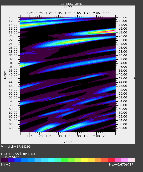
| Estimated Moho Depth: |
17.0 km |
| Estimated Crust Vp/Vs: |
2.10 |
| Assumed Crust Vp: |
6.1 km/s |
| Estimated Crust Vs: |
2.908 km/s |
| Estimated Crust Poisson's Ratio: |
0.35 |
|
| Radial Match: |
87.83193 % |
| Radial Bump: |
400 |
| Transverse Match: |
71.640015 % |
| Transverse Bump: |
400 |
| SOD ConfigId: |
4714 |
| Insert Time: |
2010-03-09 06:38:08.932 +0000 |
| GWidth: |
2.5 |
| Max Bumps: |
400 |
| Tol: |
0.001 |
|

Signal To Noise
| Channel | StoN | STA | LTA |
| GE:IBBN: :BHN:20021117T05:04:10.902Z | 29.623875 | 6.875565E-6 | 2.3209539E-7 |
| GE:IBBN: :BHE:20021117T05:04:10.902Z | 20.393572 | 3.4485656E-6 | 1.6910063E-7 |
| GE:IBBN: :BHZ:20021117T05:04:10.902Z | 67.72136 | 1.8672772E-5 | 2.757294E-7 |
| Arrivals |
| Ps | 3.1 SECOND |
| PpPs | 8.4 SECOND |
| PsPs/PpSs | 12 SECOND |


