You are here: Home > Network List > N4 - Central and EAstern US Network Stations List
> Station M44A Midewin, Midewin Nat. Tallgrass Prarie, IL, USA > Earthquake Result Viewer
M44A Midewin, Midewin Nat. Tallgrass Prarie, IL, USA - Earthquake Result Viewer
| Earthquake location: |
Northern Mid-Atlantic Ridge |
| Earthquake latitude/longitude: |
47.3/-27.3 |
| Earthquake time(UTC): |
2021/03/20 (079) 01:49:18 GMT |
| Earthquake Depth: |
10 km |
| Earthquake Magnitude: |
5.8 Mww |
| Earthquake Catalog/Contributor: |
NEIC PDE/us |
|
| Network: |
N4 Central and EAstern US Network |
| Station: |
M44A Midewin, Midewin Nat. Tallgrass Prarie, IL, USA |
| Lat/Lon: |
41.39 N/88.04 W |
| Elevation: |
207 m |
|
| Distance: |
42.9 deg |
| Az: |
285.253 deg |
| Baz: |
60.798 deg |
| Ray Param: |
0.072913945 |
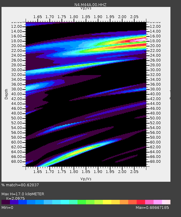
| Estimated Moho Depth: |
17.0 km |
| Estimated Crust Vp/Vs: |
2.10 |
| Assumed Crust Vp: |
6.498 km/s |
| Estimated Crust Vs: |
3.098 km/s |
| Estimated Crust Poisson's Ratio: |
0.35 |
|
| Radial Match: |
80.62837 % |
| Radial Bump: |
400 |
| Transverse Match: |
59.38223 % |
| Transverse Bump: |
378 |
| SOD ConfigId: |
24334971 |
| Insert Time: |
2021-04-03 02:05:39.663 +0000 |
| GWidth: |
2.5 |
| Max Bumps: |
400 |
| Tol: |
0.001 |
|

Signal To Noise
| Channel | StoN | STA | LTA |
| N4:M44A:00:HHZ:20210320T01:56:45.740Z | 0.87397593 | 5.5302513E-7 | 6.327693E-7 |
| N4:M44A:00:HH1:20210320T01:56:45.740Z | 1.2666491 | 6.105866E-7 | 4.8204873E-7 |
| N4:M44A:00:HH2:20210320T01:56:45.740Z | 3.41788 | 1.1805748E-6 | 3.4541145E-7 |
| Arrivals |
| Ps | 3.0 SECOND |
| PpPs | 7.7 SECOND |
| PsPs/PpSs | 11 SECOND |


