You are here: Home > Network List > GE - GEOFON Stations List
> Station IBBN RUB/GEOFON Station Ibbenbueren, Germany > Earthquake Result Viewer
IBBN RUB/GEOFON Station Ibbenbueren, Germany - Earthquake Result Viewer
| Earthquake location: |
Kuril Islands |
| Earthquake latitude/longitude: |
47.2/151.3 |
| Earthquake time(UTC): |
2004/07/08 (190) 10:30:49 GMT |
| Earthquake Depth: |
128 km |
| Earthquake Magnitude: |
5.9 MB, 6.4 MW, 6.3 MW |
| Earthquake Catalog/Contributor: |
WHDF/NEIC |
|
| Network: |
GE GEOFON |
| Station: |
IBBN RUB/GEOFON Station Ibbenbueren, Germany |
| Lat/Lon: |
52.31 N/7.76 E |
| Elevation: |
140 m |
|
| Distance: |
76.1 deg |
| Az: |
337.923 deg |
| Baz: |
24.673 deg |
| Ray Param: |
0.05092197 |
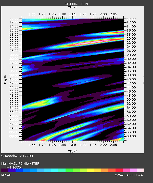
| Estimated Moho Depth: |
21.75 km |
| Estimated Crust Vp/Vs: |
1.94 |
| Assumed Crust Vp: |
6.1 km/s |
| Estimated Crust Vs: |
3.148 km/s |
| Estimated Crust Poisson's Ratio: |
0.32 |
|
| Radial Match: |
82.17793 % |
| Radial Bump: |
400 |
| Transverse Match: |
71.79739 % |
| Transverse Bump: |
400 |
| SOD ConfigId: |
2459 |
| Insert Time: |
2010-03-09 06:38:35.098 +0000 |
| GWidth: |
2.5 |
| Max Bumps: |
400 |
| Tol: |
0.001 |
|

Signal To Noise
| Channel | StoN | STA | LTA |
| GE:IBBN: :BHN:20040708T10:41:51.685024Z | 4.517004 | 9.042467E-7 | 2.0018727E-7 |
| GE:IBBN: :BHE:20040708T10:41:51.685024Z | 2.3221347 | 6.8683784E-7 | 2.9577865E-7 |
| GE:IBBN: :BHZ:20040708T10:41:51.685024Z | 12.836615 | 2.7939702E-6 | 2.1765631E-7 |
| Arrivals |
| Ps | 3.4 SECOND |
| PpPs | 10 SECOND |
| PsPs/PpSs | 14 SECOND |


